AfreSlide: Landslides in Equatorial Africa: Identifying culturally, technically and economically feasible resilience strategies
.jpg)
AfReSlide (2013-2018) is a scientific project funded by the Belgian Federal Scientific Policy (Belspo), as part of the Belgian Research Action through Interdisciplinary Networks (BRAIN-be)
Landslides cause significant impacts in Equatorial Africa: they cause fatalities and result in structural and functional damage to infrastructure and properties, as well as serious disruptions of the organization of societies.
Information on landslides is far more limited in Equatorial Africa as compared to other continents. There are very few data at the continental and regional scale and it is difficult to have a clear picture of the total area affected.
The impact of landslides on individuals and societies results from (1) the occurrence of landslides and subsequent floods (landslide HAZARD), (2) the presence of human activities and infrastructure in landslide-prone areas (EXPOSURE) and (3) the potential losses due to the occurrence of landslides (VULNERABILITY). Landslide risk can therefore be considered to result from the product of RISK = HAZARD * EXPOSURE * VULNERABILITY.
According to this formula, resilience of a society (or people) towards landslides depends on factors affecting one, or several, of these three variables. Losses from LS are expected to increase in the future in response to the demographic pressure causing more development in landslide-prone areas, deforestation and associated changes in land use and land cover, and the changing climate causing higher or more intense rainfalls.
OBJECTIVE
The main objective is to develop an integrated and broadly applicable methodology for landslide resilience analysis in data-poor environments in Equatorial Africa and apply this in four study areas seriously suffering from landslides in Uganda and Cameroon.
Specific objectives:
- To produce landslide susceptibility maps and identify return periods of landslide-triggering rainfall events in order to estimate landslide hazards in the 4 representative areas (WP1);
- To analyze the types of elements at risk (immaterial and material) and their exposure, and to develop a methodology to economically value the consequences (WP2);
- To assess resilience strategies at household and at policy levels (WP3);
- To analyze the cultural premises underlying perceptions of environmental threats, to describe land rights and land management, and to identify culturally acceptable resilience strategies (WP4);
- To produce hazard and risk maps develop a toolbox to identify the most effective and acceptable resilience strategies (WP5).
STUDY AREAS
Both Cameroon and Uganda stand as examples for the steep, highly weathered areas of the wet tropics that face a high population density and pressure. People encroach steep slopes and clear forest to get access to land for building their houses and generating an income through agriculture. In both countries, the local population and stakeholders are aware of the landslide risk but struggle to implement efficient resilience strategies, due to the lack of enforced land use plans and the high pressure on the land. Therefore local stakeholders are urgently demanding to investigate efficient resilience strategies that would be acceptable for the local population, adapted to their livelihood and enabling a safer and sustainable development of the region.
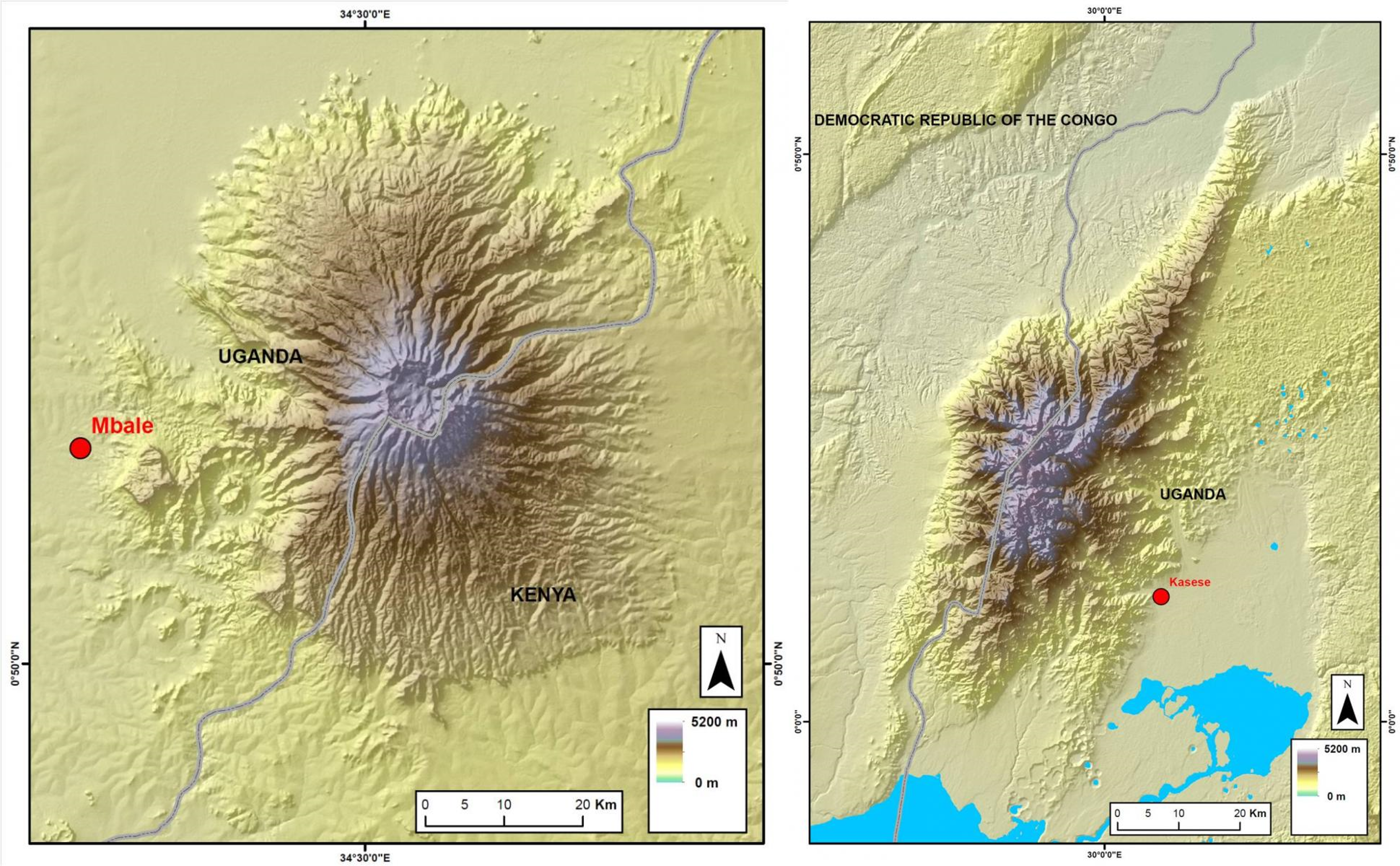
In the Ugandan study areas, both shallow and deep-seated landslide are frequently occurring on the densely populated footslopes of Mt Elgon and Mt Rwenzori. From 2010 to 2012, over 500 people were killed by dramatic deep-seated LS in the Mt Elgon region. As very few information is available for the Rwenzori region, while there are strong indications that landslides are a big problem in the region, it will be the major study area for the project.
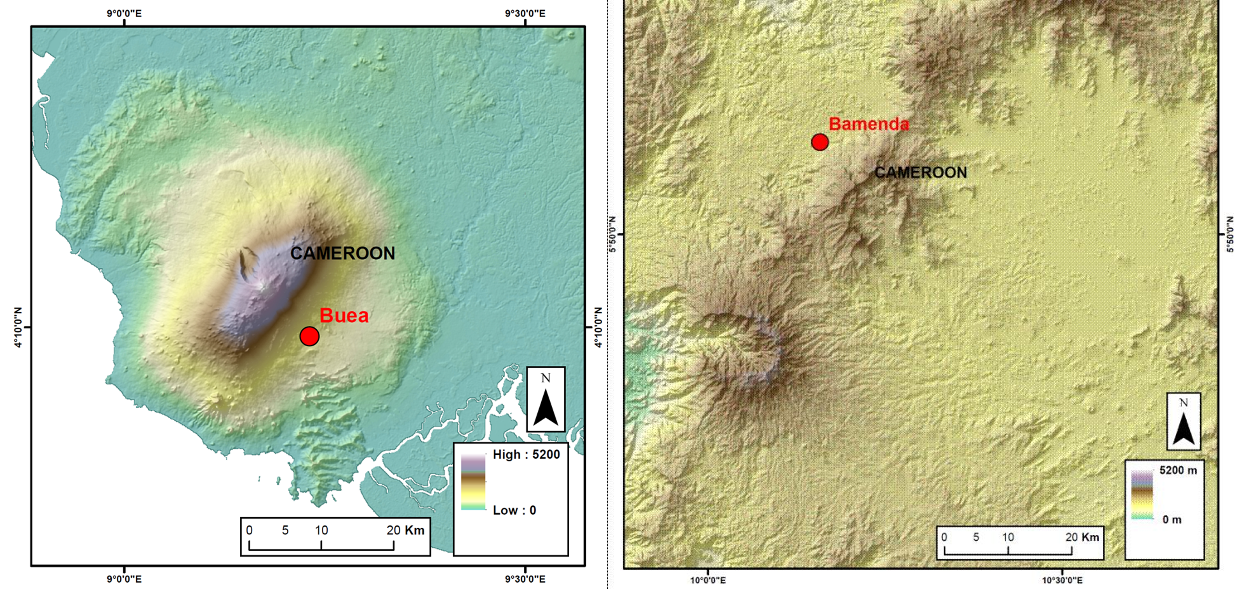
Along the Cameroon Volcanic Line in the NW and SW provinces of Cameroon, dominantly shallow translational landslide affect the steep and highly weathered residual soils formed on dominantly volcanic rocks. Several fatalities and major economic disruptions are experienced every year. Two study areas have been identified in SW Cameroon: the semi-urban and urban region around Limbé and the Bamenda region.
METHOD
The work within this project is organized around five scientific work packages, which approach the problem at different scales and with different methodologies. An additional sixth work package consists of project management, communication and valorisation.
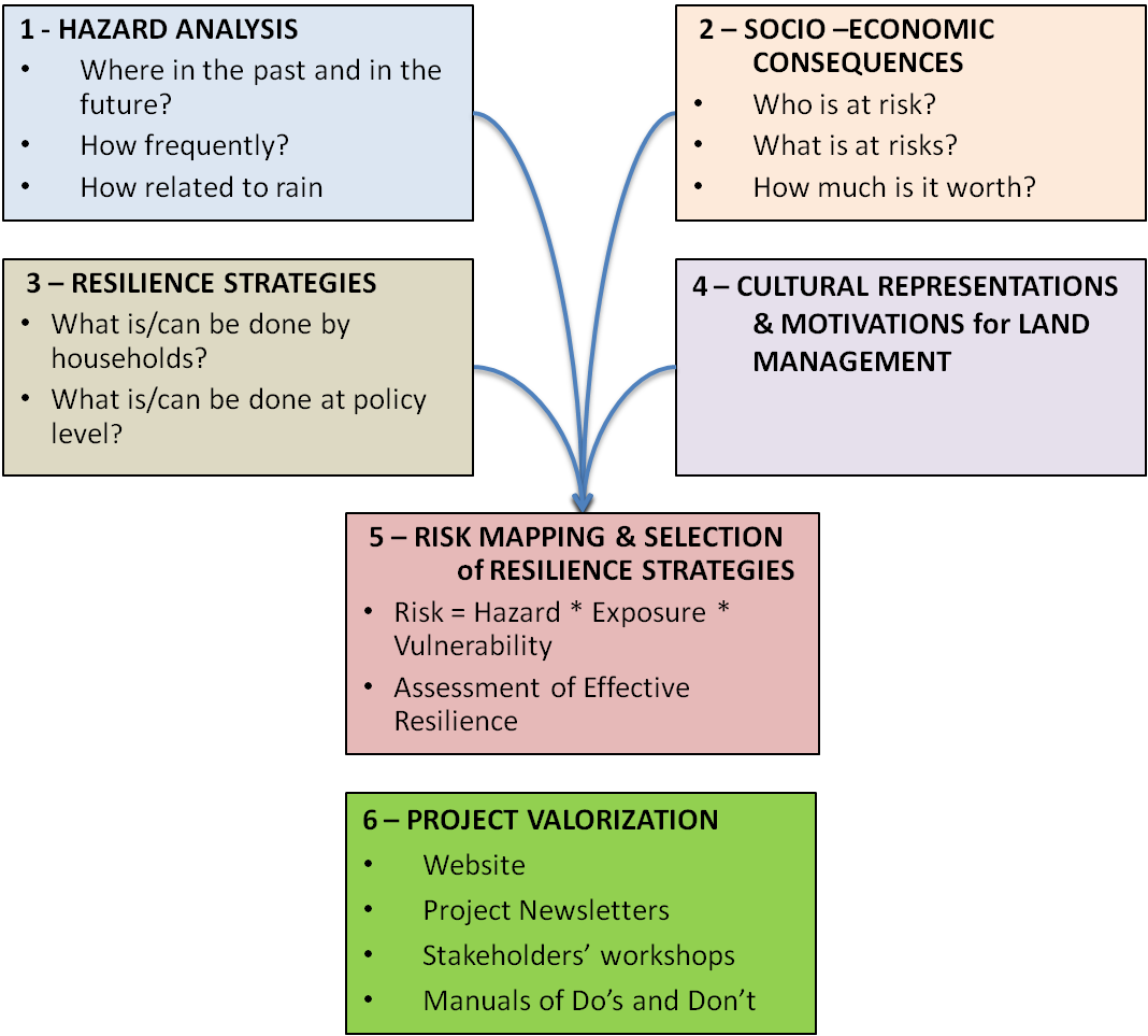
- WP1 assesses landslide susceptibility at a regional scale within the 4 targeted regions. It does so by first calibrating existing susceptibility and hazard models for various types of landslides in the study areas based on a detailed inventory of recent landslides and secondly developing physically-based models, by intensive data collection in representative sub-regions.
- WP2 evaluates the exposure and potential loss degree of the elements at risk in some of the study areas. It estimates both the direct, indirect and intangible damage of landslides in a semi-quantitative way, by mapping elements at risk with the use of satellite imagery, interviews of key informants, group discussions and a structured household survey in the region.
- WP3 is strongly linked to WP2 and aims at evaluating the effectiveness of the currently implemented resilience strategies at household and at policy levels. Existing resielience strategies in the field are mapped and compared with state of the art geotechnical and policy tools in recent literature. The approach towards mapping of the strategies is semi-quantitative, combining interviews of key informants, group discussions and a structured household survey.
- WP4 attempts to understand the community dynamics and their relationship to land, their environment and its hazards. Key informants are interviewed to identify and describe cultural premises and representations related to natural hazards, the extent of solidarity networks and the leadership structure. Relevant means of communication to inform the people about possible resilience strategies will be identified.
- WP5 combines into effective risk maps the information gathered in previous work packages. A flexible GIS tool will be developed, enabling scientists from local institutions to update the risk assessment based on updated hazard and vulnerability maps. This GIS tool will also be used to test the influence of climate and land use change scenarios on the resulting risk estimates.
- WP6 aims at insuring the coordination of the actions of the different project partners and the interactions between the different work packages. It does so by organizing regular stakeholder meetings, workshops, the dissemination of information in a newsletter and on the website,...
CONSORTIUM
![]()


RESEARCH OUTPUTS
Scientific papers
- Maes, J., Kervyn, M., de Hontheim, A., Dewitte, O., Jacobs, L., Mertens, K., Vanmaercke, M., Vranken, L., Poesen, J., 2017. Landslide risk reduction strategies: A review of practices and challenges for the tropics. Progress in Physical Geography, 41(2), 191-221 [I.F. 2.612]. DOI: 10.1177/0309133316689344
- Jacobs, L., Dewitte, O., Kabaseke, C., Kervyn, F., Maes, J., Mertens, K., Nobile, A., Sekajugo, J., Poesen, J., Samyn, D., Kervyn, M., 2017. Landslide Diversity in the Rwenzori Mountains (Uganda). Advancing Culture of Living with Landslides, pp.79-86. DOI: 10.1007/978-3-319-53498-5_10.
- Jacobs, L., Maes, J., Mertens, K., Sekajugo, J., Thiery, W., van Lipzig, N., Poesen, J., Kervyn, M., Dewitte, O., 2017. Flash Floods in the Rwenzori Mountains—Focus on the May 2013 Multi-Hazard Kilembe Event. Advancing Culture of Living with Landslides, pp.631-641. DOI: 10.1007/978-3-319-53485-5_73.
- Maes, J., Parra, C., Poesen, J., Vranken, L., Dewitte, O., Kabaseke, C., Bosco Bwambale, B., Mertens, K., Jacobs, L., de Hontheim, A., and Kervyn, M., 2017. A multi-policy level approach for landslide risk management in Uganda. In: World Landslide Forum 4, Vol. 3, Advances in Landslide Technology (ed. Željko Arbanas), Springer Nature.
- Mertens, K., Jacobs, L., Maes, J., Kabaseke, C., Maertens, M., Poesen, J., Kervyn, M., Vranken, L., 2016. The direct impact of landslides on household income in tropical regions: a case study on the Rwenzori Mountains in Uganda. Science of the Total Environment, doi:10.1016/j.scitotenv.2016.01.171
- Matthieu, K., Liesbet, J., Maes, J., Bih Che, V., de Hontheim, A., Dewitte, O., Isabirye, M., Sekajugo, J., Kabaseke, C., Poesen, J., Vranken, L., Mertens, K. 2016. Landslide resilience in Equatorial Africa: Moving beyond problem identification! Belgeo. doi: 10.4000/belgeo.15944
- Jacobs, L., Maes, J., Mertens, K. et al. Nat Hazards (2016). Reconstruction of a flash flood event through a multi-hazard approach: focus on the Rwenzori Mountains, Uganda. Natural Hazards. doi:10.1007/s11069-016-2458-y [I.F. 1.72].
- Jacobs, L., Dewitte, O., Poesen, J., Maes, J., Mertens, K., Sekajugo, J., Kervyn, M., 2016. Landslide characteristics and spatial distribution in the Rwenzori Mountains, Uganda. Journal of African Earth Sciences [I.F. 1.403].
- Jacobs, L., Dewitte, O., Poesen, J., Delvaux, D., Thiery, W., Kervyn, M., 2015. The Rwenzori Mountains, a landslide-prone region?. Landslides, doi: 10.1007/s10346-015-0582-5. [I.F. 2.870]
For more information, please visit the AfreSlide website.
Project description also available on the AfricaMuseum website.
![]()