GeoRisCA: Geo-risk in Central Africa: integrating multi-hazards and vulnerability to support risk management
![]()
GeoRisCA (2012-2016) is a scientific project funded by the Belgian Federal Scientific Policy (Belspo).
The project is coordinated by the Royal Museum for Central Africa, in collaboration with the Université Libre de Bruxelles, the Université de Liège, the Vrije Universiteit Brussel and the European Center of Geodynamics and Seismology. It is conducted in close collaboration with local partners from the three targeted countries (Burundi, DRC and Rwanda).
The region of interest corresponds to the centre of the western branch of East African rift valley extending from North Tanganyika region to the Virunga Volcanic Province (VVP). That densely populated area is affected by a combination of several types of geohazards.
Earthquakes
The region is characterized by a strong seismicity (800 “felt seisms” between 1909 and 1954 in DRC, Rwanda and Burundi; the greatest historical known earthquakes in East Africa, in terms of magnitude, recorded close to the studied region). Recently, moderate magnitude earthquakes have hit the Kivu basin area and caused important damages and casualties (e.g. 2008 Bukavu-Cyangugu Mw 5.9). Due to the demographic increase, more and more people and infrastructures are exposed to the seismic risk in these regions.
Volcanoes
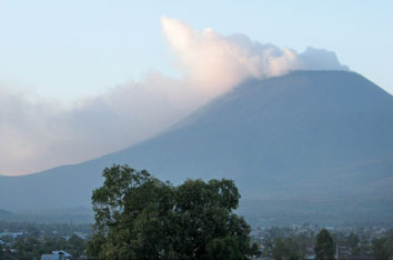
The dormant volcanoes in the Eastern part of the VVP represent a potential threat but require more assessment. The region also hosts the two most active volcanoes of Africa: Nyiragongo and Nyamulagira. Their activities have serious impacts on the environment (e.g. 927 ha of tropical primary forest devastated during the 2010 Nyamulagira eruption). Its neighbour, the Nyiragongo volcano, hosts a (semi-) permanent ~200 m wide lava lake, the largest on Earth. In Africa, this volcano is also probably the most dangerous to human beings as it directly threatens the ~700.000 inhabitants of Goma city, which is located ~15 km south. In January 2002, such as in 1977, fissures opened on the southern flank of the volcano and fast lava flows destroyed about 10 % of the city, killed nearly 150 persons, made 100.000 people homeless and triggered a humanitarian crisis. The long-term socio-economic impact is still felt nowadays.
Goma is a strategic economic centre for the Great Lake Region and its population is growing rapidly, also due to the important displaced populations that settle in camps during conflicts. In addition, the high concentration of volcanic CO2 gas dissolved in the lake Kivu water could potentially lead to a limnic eruption, i.e. a brutal gas release leading to massive casualties by asphyxiation in the whole region (e.g. lake Nyos in Cameroun in 1986). A sub-lacustrine magmatic eruption or a major landslide are considered as possible trigger mechanisms for a lake overturn. The passive volcanic degassing causes CO2 accumulation in on-land depressions up to lethal concentration, called mazuku. That hazard is observed in many areas along the northern shore of Lake Kivu including Goma and Sake urban centers where it represents a serious danger to the population and cattle.
Mass movements
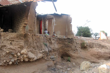
Throughout the targeted region, landslides – mass movement of a portion of the slope or the slope itself (soil or rock) – represent the most severe hazard at local scale. A chronological and spatial inventory of geologic/geomorphic events that occurred in the DRC, Rwanda and Burundi since 1900 is shown by the on-line database compiled by the RMCA. In the study area, mass movements can be triggered both by climatic events (strong rainfall) as well as seismic or volcanic activity. The potential impact of these landslides is increased by anthropogenic factors. In cities such as Bujumbura and Uvira, for instance, both the rift escarpment and the Lake Tanganyika limit urban expansion, forcing people to settle on unstable slopes.
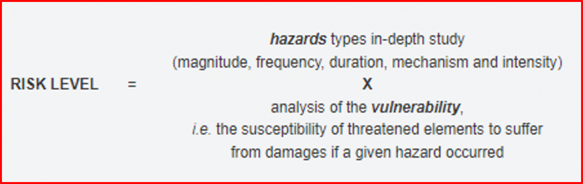
Such disasters, unforeseen and often sudden events, are the result of the spatial conjunction of a hazard and vulnerable stakes (people, assets, lifelines, activities) in a given place and time. It is fundamental to try assessing the probability of occurrence of a disaster (i.e. the risk).
Vulnerability
Vulnerability is measured through the exposure to perturbations and the adaptive capacity or resilience of the vulnerable systems.
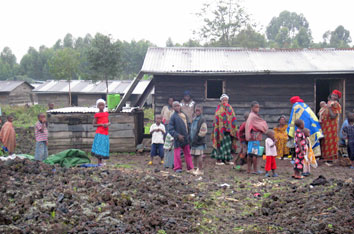
An added value of GeoRisCA is to develop a methodology to assess the vulnerability to multi geohazards within the studied area at regional and at local scale, for selected urban sites, considering the evolution of vulnerability through time, e.g. due to improved education, increased income, denser social networks and evolution of coping mechanisms.
Risk perception
The risk assessment is influenced by an additional factor: the risk perception. People's behaviour when facing a danger are not only influenced by the socio-economic context, but also by their hazard knowledge, the role of political institutions and the role of religion. In summary, people with the higher risk perception are likely to be best prepared in the event of a disaster.
OBJECTIVE
General objective
The main objective is the assessment of the georisk in the Lake Kivu region (DRC, Rwanda, Burundi), by analysing and combining seismic, volcanic and mass-movement hazards as well as the vulnerability of the population, the infrastructures and the natural ecosystems, in order to support risk management.
Most threatening at regional scale are the seismic hazard and the regular eruptions of the two active volcanoes of the Virungas that could strongly affect this high densely populated and vulnerable area. Possible impacts of lethal gas in certain area around Goma city, and the large number of reported and forecasted mass movements, as well as site-specific seismic amplification effects increase the danger at local scale.
GeoRisCA assessment will take the form of dynamic maps and databases based on a comprehensive methodology.
The local and regional authorities, as well as local and international stakeholders, will benefit from essential documents to (1) develop more efficient disaster response mechanisms and (2) help them improve land planning and the implementation of development programs.
Specific objectives
- Contribute to a better assessment of the targeted geohazards at regional scale and in specific areas, such as urban context;
- Evaluate the global vulnerability of populations to these geohazards, a study which has never been undertaken in that region, although more than 3 millions of people live in the region under study;
- Develop a risk assessment methodology, which will allow to rapidly obtain a updated risk portrait of a specific area when needed;
- Deliver a series of regional and local risk maps presenting a large number of hazards and vulnerability indicators that should help decision-making;
- Enforce risk management processes through communication of the results with existing preparedness and mitigation institutions, as well as authorities and other concerned organisations.
METHOD
An innovative approach based on the integration of various scientific methodologies is developed in GeoRisCA. Methods from geology, geophysics, geomorphology, geography, and anthropology are associated in order to provide a realistic image of the risk in the target region.
The developed methodology at the local scale combines hazard and vulnerability factors, as well as risk perception indicators. The collected quantitative and qualitative data are standardised and compiled into a Geographical Information System (GIS) according to a specific weighting.
The precise methodology is based both on the literature and on the advice of experts of risk assessment and local stakeholders.
The risk assessment is defined at the regional and local (urban) scales; moreover, GeoRisCA provides an evolving picture of the risk level, by taking into account the variations of the geohazards and the vulnerability factors and the coping mechanisms that people developed in order to face geohazards.
A series of maps as decision-making tools will be produced, highlighting various aspects of the risk, depending on the hazards type, the scale and the potential use.
CONSORTIUM
![]()

![]()
RESEARCH OUTPUTS
Reports
- Descriptive brochure of GeoRisCA project (12/2016)
- Reportage Matière Grise broadcasted the first time in June 2012
- Article in Flanders Today (18/06/2014)
- Interview of B. Smets in La Meuse (23/07/2014)
- Interview of S. Poppe in P-Magazine (06/09/2014)
Scientific papers
- Barette, F., Poppe, S., Smets, B., Benbakkar, M. & Kervyn, M. (2017). Spatial variation of volcanic rock geochemistry in the Virunga Volcanic Province: Statistical analysis of an integrated database. Journal of African Earth Sciences, http://doi.org/10.1016/j.jafrearsci.2016.09.018.
- Delvaux, D., Mulumba, J.-L., Sebagenzi, M.N.S., Fiama Bondo, S., Kervyn, F., Havenith, H.-B. (2017). Seismic hazard assessment of the Kivu rift segment based on a new sismo-tectonic zonation model (Western Branch, East African Rift system). Journal of African Earth Sciences. http://doi.org/10.1016/j.jafrearsci.2016.10.004.
- Ganza Bamulezi, G., Mavonga Tuluka, G., Delvaux, D. (2016). Analyse sismotectonique de quelques failles actives de la partie occidentale du rift du Kivu en République démocratique du Congo (RDC). Geo-Eco-Trop.
- Geirsson, H., d’Oreye, N., Mashagiro, N., Syauswa, M., Celli, G., Kadufu, B., Smets, B. & Kervyn, F.. (2016) Volcano-tectonic deformation in the Kivu Region, Central Africa: Results from six years of continuous GNSS observations of the Kivu Geodetic Network (KivuGNet). Journal of African Earth Sciences.
- Ji, K.H., Stamps, S.D., Geirsson, H., Mashagiro, N., Syauswa, M., Kafudu, B., Subira, J. & d’Oreye, N. (2017). Deep magma accumulation at Nyamulagira volcano in 2011 detected by GNSS observations. Journal of African Earth Sciences, ISSN 1464-343X, http://dx.doi.org/10.1016/j.jafrearsci.2016.06.006.
- Li, L., Canters, F., Solana, C., Ma, W., Chen, L. & Kervyn, M. (2015). Discriminating lava flows of different age within Nyamuragira’s volcanic field using spectral mixture analysis. International Journal of Applied Earth Observation and Geoinformation, 40, 1-10.
- Michellier, C., Pigeon, P., Kervyn, F. & Wolff, E. (2016). Contextualizing vulnerability assessment: a support to geo-risk management in central Africa. Natural Hazards. Vol. 82 pp 27-42. http://doi.org/10.1007/s11069-016-2295-z.
- Mossoux, S., Delcamp, A., Poppe, S., Michellier, C., Canters, F. & Kervyn M. (2016). Hazagora: will you survive the next disaster? – A serious game to raise awareness about geohazards and disaster risk reduction. Natural Hazard and Earth System Science, 16, 135-147, http://dx.doi.org/10.5194/nhess-16-1-2016.
- Mossoux, S., Saey, M., Bartolini, S., Poppe, S., Canters, F. & Kervyn, M. (2016). Q-LAVHA: A flexible GIS plugin to simulate lava flows. Computers & Geosciences, 97, 98-109.
- Poppe, S., Smets, B., Fontijn, K., Rukeza, M.B., De Marie Fikiri Migabo, A., Milungu, A.K., Namogo, D.B., Kervyn, F. & Kervyn, M.. (2016) Holocene phreatomagmatic eruptions alongside the densely populated northern shoreline of Lake Kivu, East-African Rift: timing and hazard implications. Bulletin of Volcanology.
- Ross K.A., Smets B., De Batist M., Hilbe M., Schmid M., Anselmetti F.S. (2014). Lake-level rise in the late Pleistocene and active subaquatic volcanism since the Holocene in Lake Kivu; East African Rift. Geomorphology 221, 274-285 – http://doi.org/10.1016/j.geomorph.2014.05.010.
- Ross, K.A., Smets, B., De Batist, M., Hilbe, M., Schmid, M. & Anselmetti, F.S. (2014). Lake-level rise in the late Pleistocene and active subaquatic volcanism since the Holocene in Lake Kivu, East African Rift. Geomorphology, 221, 274–285.
- Samsonov S., d’Oreye N., Smets B.. (2013). Ground deformation associated with post-mining activity at the French-German border revealed by novel InSAR time series method. International Journal of Applied Earth Observation and Geoinformation 23, 142-154. http://doi.org/10.1016/j.jag.2012.12.008
- Samsonov, S., d'Oreye, N. & Smets, B. (2013). Natural and anthropogenic ground deformation monitored using high spatio-temporal resolution MSBAS time series method. Proc. MultiTemp 2013 Workshop : 7th International Workshop on the Analysis of Multi-Temporal Remote Sensing Images: “Our Dynamic Environment,” 1–3.
- Smets B., d’Oreye N., Kervyn F., Kervyn M., Albino F., Arellano S.R., Bagalwa M., Balagizi C., Carn S.A., Darrah T.H., Fernández J., Galle B., González P.J., Head E., Karume K., Kavotha D., Lukaya F., Mashagiro N., Mavonga G., Norman P., Osodundu E., Pallero J.L.G., Prieto J.F., Samsonov S., Syauswa M., Tedesco D., Tiampo K., Wauthier C., Yalire M.M. 2014. Detailed multidisciplinary monitoring reveals pre- and co-eruptive signals at Nyamulagira volcano (North Kivu, Democratic Republic of Congo). Bulletin of Volcanology 76 (1): 787, 35p. http://doi.org/10.1007/s00445-013-0787-1
- Smets, B., d’Oreye, N., Kervyn, M. & Kervyn, F. Eruptive activity of Nyiragongo volcano: the true figures. Bulletin of Volcanology.
- Smets, B., Delvaux, D., Ross, K.A., Poppe, S., Kervyn, M., d’Oreye, N. & Kervyn, F. (2016). The role of inherited crustal structures and magmatism in the development of rift segments: Insights from the Kivu basin, western branch of the East African Rift. Tectonophysics, 683, 62-76. http://doi.org/10.1016/j.tecto.2016.06.022
- Smets, B., Delvaux, D., Ross, K.A., Poppe, S., Kervyn, M., d’Oreye, N., Kervyn, F. (2016). The role of inherited crustal structures and magmatism in the development of rift segments: Insights from the Kivu basin, western branch of the East African Rift. Tectonophysics 683, 62-76. http://doi.org/10.1016/j.tecto.2016.06.022
- Smets, B., d'Oreye, N., & Kervyn, F. (2014). Toward Another Lava Lake in the Virunga Volcanic Field? EOS Transactions American Geophysical Union 95 (42), 377–378. http://doi.org/10.1002/2014EO420001 (Peer-reviewed press article).
- Smets, B., d'Oreye, N., Kervyn, F., Kervyn, M., Albino, F., Arellano, S. R., et al. (2014). Detailed multidisciplinary monitoring reveals pre- and co-eruptive signals at Nyamulagira volcano (North Kivu, Democratic Republic of Congo). Bulletin of Volcanology, 76(1), 787. http://doi.org/10.1007/s00445-013-0787-1
- Smets, B., d'Oreye, N., Kervyn, M. & Kervyn, F.. (2016) Gas piston activity of the Nyiragongo lava lake: First insights from a Stereographic Time-Lapse Camera system. Journal of African Earth Sciences, http://dx.doi.org/10.1016/j.jafrearsci.2016.04.010.
- Smets, B., Kervyn, M., d’Oreye, N. & Kervyn F. (2015). Spatio-temporal dynamics of eruptions in a youthful extensional setting: insights from Nyamulagira volcano (D.R. Congo), in the western branch of the East African Rift. Earth Science Reviews, 150, 305-328.
- Syavulisembo A, Havenith H.-B., Smets B., d’Oreye N., Marti J.. (2015) Preliminary assessment for the use of VORIS as a tool for rapid lava flow simulation at Goma Volcano Observatory, DR Congo. Nat. Hazards Earth Syst. Sci., 15, 2391–2400
- Trefon, T. & Kabuyaya, N.. (2016). Précarité et bien-être à Goma (RDC). Cahiers Africains, L'Harmattan. 200 pages. ISBN : 978-2-343-10503-1.
- Wauthier C., Smets B. & Keir D. (2015). Diking-induced moderate-magnitude earthquakes on a youthful rift border fault: The 2002 Nyiragongo-Kalehe sequence, D.R. Congo. Geochemistry, Geophysics, Geosystems, 16, 4280-4291.
Conference proceedings
- d’Oreye N., Samsonov S., Geirsson H., Nobile A., Derauw D., Kervyn F.. Multidimensional InSAR time series analysis (MSBAS) for natural and anthropogenic hazards monitoring. Abstract, European Space Agency Living Planet Symposium, May 9-13 2016, Prague, Czech Republic.
- Nobile A., Smets B., d’Oreye N., Geirsson H., Kervyn F.. InSAR analysis of ground displacement during the 2011-2012 Nyamulagira volcanic eruption. Abstract, European Space Agency Living Planet Symposium, May 9-13 2016, Prague, Czech Republic.
- Poppe S., Barette F., Smets B., Benbakkar M., Kervyn M.. Deriving spatial patterns from a novel database of volcanic rock geochemistry in the Virunga Volcanic Province, East African Rift. EGU General Assembly 2016, Vienna, Austria, April 17-22 2016.
- Poppe S., Grosse P., Barette F., Smets B., Albino F., Kervyn F., Kervyn M.. Quantifying the morphometric variety of satellite cones in volcanic fields: the Virunga Volcanic Province, East African Rift. EGU General Assembly 2016, Vienna, Austria, April 17-22 2016.
- Geirsson H., d’Oreye N., Smets B., Nobile A., Samsonov S., Derauw D., Mashagiro N., Kervyn F.. Volcano-tectonic deformation in the Kivu Region, Central Africa: Results from multi-year InSAR time series analysis and continuous GNSS observations of the Kivu Geodetic Network (KivuGNet). Abstract, European Geosciences Union General Assembly 2016, April 17-22 2016.
- Nobile A., Geirsson H., Smets B., d’Oreye N., Kervyn F. InSAR and GPS measurements along the Kivu segment of the East African Rift System during the 2011-2012 Nyamulagira volcanic eruption. Abstract, European Geosciences Union General Assembly 2016, April 17-22 2016.
- Smets B., d’Oreye N., Kervyn M., Kervyn F.. Parameters influencing the location and characteristics of volcanic eruptions in a youthful extensional setting: Insights from the Virunga Volcanic Province, in the Western Branch of the East African Rift System. Abstract, European Geosciences Union General Assembly 2016, April 17-22 2016.
- Nobile A., Monsieur E., Dewitte O., d’Oreye N., Kervyn F.. Multi-temporal InSAR monitoring of landslides in a tropical urban environment: focus on Bukavu (DR Congo). Abstract, European Geosciences Union General Assembly 2016, April 17-22 2016.
- Smets B., d’Oreye N., Geirsson H., Kervyn M., Kervyn F.. Insights into the dynamics of the Nyiragongo lava lake level. Abstract, European Geosciences Union General Assembly 2016, April 17-22 2016.
- Geirsson H., Smets B., d’Oreye N., Cayol V., Samsonov S., Derauw D., Kervyn F.. Source processes of near-field deformation accompanying recent lava lake level decrease at Nyiragongo, DR. Congo. Abstract, European Geosciences Union General Assembly 2016, April 17-22 2016.
- Fonseca J., d’Oreye N.. Geophysical monitoring of African volcanoes: examples from Cape Verde and DRC. Abstract, 11th Annual AfricaArray Workshop, 17-23 January 2016, Univ. Witwatersrand, Johannesburg, South Africa.
- d’Oreye N., Samsonov S.. Advanced multidimensional high spatiotemporal resolution DInSAR time series analysis applied to ground deformation of natural and anthropogenic origin. Abstract, The Dark Side of Remote Sensing, December 9 2015, BELSPO, Brussels, Belgium.
- Shimoni, M., Lopez, J.F., Forget, Y., Wolff, E., Michellier, C., Grippa, T., Linard, C., & Gilbert, M. An urban expansion model for African cities using fused multi temporal optical and SAR data. Geoscience and Remote Sensing Symposium (IGARSS), July 2015, (page 1159-1162).
- Poppe S., Grosse P., Smets B., Albino F., Kervyn F., Kervyn M. Spatial distribution and morphology of satellite cones in the Virunga Volcanic Province (Rwanda, Uganda and Democratic Republic of Congo). IUGG General Assembly 2015, Prague, Czech Republic, June 22-July 2 2015.
- Delvaux D., Smets B.. Initiation and development of the Kivu rift segment in Central Africa by reactivating un-favorably oriented structural weaknesses. EGU General Assembly 2015, Vienna, Austria, April 12-17 2015.
- Dewitte O., Monsieurs E., Jacobs L. , Basimike J., Delvaux D., Draida S., Hamenyimana JB., Havenith HB., Kubwimana D., Maki Mateso JC., Michellier C., Nahimana L., Ndayisenga A., Ngenzebuhoro PC., Nkurunziza P., Nshokano JR., Sindayihebura B., Trefois P., Turimumahoro D. and F. Kervyn (2015). Mapping landslide processes in the North Tanganyika – Lake Kivu rift zones: towards a regional hazard assessment. Geophysical Research Abstracts, 17, EGU2015-6726, EGU conference 2015, Vienna.
- Mossoux S., Delcamp A., Poppe S., Canters F., Kervyn M.. KAZAN: Will you survive the next geodisaster? An educational game for raising awareness about geohazards and risk reduction strategies. Geophysical Research Abstracts, Oral presentation. EGU General Assembly 2015, Vienna - Austria.
- d’Oreye N. , Smets B., De Rauw D., Arjona A., Albino F., Geirsson H., Nobile A. and Kervyn F., InSAR Remote Sensing of Active Craters in the Virunga Volcanic Province, DR Congo. Proc. of the 9th ESA FRINGE2015 workshop, ESA-ESRIN, Frascati, Italy, March 23-27 2015.
- Kervyn F. and d’Oreye N., Framework of research in the Kivu rift Basin context (Central Africa – Great Lakes Region), Proc. of the 9th ESA FRINGE2015 workshop, ESA-ESRIN, Frascati, Italy, March 23-27 2015. (Annex 25)
- Kervyn F., d’Oreye N. , Albino F., De Rauw D., Cayol V., Arjona A. and Nobile A., Ten years of InSAR in the Kivu Rift basin : Results and Perspectives, Proc. of the 9th ESA FRINGE2015 workshop, ESA- ESRIN, Frascati, Italy, March 23-27 2015
- De Rauw D., Kervyn F., d’Oreye N., Smets B., Albino F. and Barbier C., Split-Band Interferometric SAR Processing Using TanDEM-X Data, Proc. of the 9th ESA FRINGE2015 workshop, ESA-ESRIN, Frascati, Italy, March 23-27 2015, ESA SP-731
- d’Oreye N., Smets B., De Rauw D., Arjona A., Albino F., Geirsson H., Nobile A., Kervyn F.. InSAR Remote Sensing of Active Craters in the Virunga Volcanic Province, DR Congo. Proc. of the 9th ESA FRINGE2015 workshop, ESA-ESRIN, Frascati, Italy, March 23-27 2015
- d’Oreye N. and Arjona A., Unified Methodology for Detecting Trend Changes and Outliers in Time Series: application to Ground Deformation in the Virunga Volcanic Province. AGU Fall meeting 2014.15-19 December 2014, San Francisco, California, USA. (Annex 36)
- Kang Hyeun J., Stamps S., Geirsson H., Mashagiro N.,Syauswa M., Kafudu B., Subira J. and d’Oreye N.. Deep Magma Accumulation at Nyamulagira Volcano in 2011 Detected by GNSS Observations. Abstract, AGU Fall meeting 2014.14-18 December 2014, San Francisco, California, USA
- Smets B., d’Oreye N., Samsonov S., Nobile A., Geirsson H., Kervyn F.. Lava Lake Level Drop and Related Ground Subsidence in the Nyiragongo Main Crater (D.R.Congo) Measured by Close-Range Photogrammetry and InSAR Time-Series. Abstract, AGU Fall meeting 2014.14-18 December 2014, San Francisco, California, USA
- Smets B., Kervyn M., d’Oreye N. and Kervyn F.. Spatial and Temporal Evolution of Eruptive Activity in a Youthful Extensional Setting: the Case of the Nyamulagira Volcanic Field, Western Branch of the East African Rift, AGU Fall meeting 2014. 15-19 December 2014, San Francisco, California, USA. (Annex 34)
- Zal H.J., Wood D.A., Ebinger, C.J., Scholz C.A., d’Oreye N., Carn S.A. and Rutagarama U., Kinematics and Dynamics of the Kivu Rift System from Seismic Anisotropy, Seismicity, and Structural Analyses, AGU Fall meeting 2014. 15-19 December 2014, San Francisco, California, USA
- Poppe, S., Smets, B., Albino, F., Grosse, P., d'Oreye, N., Kervyn, F., Kervyn, M. (2014). Assessing the spatio-temporal variation of eruption hazard in a poorly known volcanic region : the Virunga Volcanic Province, Central-Africa. In Koninklijke Academie voor Overzeese Wetenschappen – Contactdag Jonge vorsers
- Arjona A., Díaz J.I., Fernández J., Convergence to Equilibrium for a Hyperbolic / Elliptic System Modelling theViscoelastic-Gravitational Deformation of a Layered Earth. Dynamical Systems and Differential Equations, DCDS Supplement 2014 Proceedings of the 11th AIMS International Conference (Madrid , Spain)
- Kervyn F., d’Oreye N., Derauw D., Albino F. and Smets B., Vi-X (STEREO-II 2012 – 2014): Study and Monitoring of Virunga volcanoes using TanDEM-X, BEODAYS 2014, 20 nov. 2014, Lier, Belgium
- Arjona A. and d’Oreye N., Methodologies and Analysis of Ground Deformations at Volcanic Areas: applications to Virunga Volcanic Province. GEORISK2014, Nov. 18-21 2014, Madrid, Spain. (Annex 35)
- Mossoux S., Delcamp A., Poppe S., Canters F., Kervyn M.. KAZAN: will you survive the next disaster? - An educational game to raise awareness about geohazards and disaster risk reduction. Oral presentation. GEORISK2014, Nov. 18-21 2014, Madrid, Spain
- Mossoux S., Bartolini S., Feltz A., Poppe S., Canters F., Kervyn M.. Q-LavHA: a Quantum GIS plugin to simulate lava flows. Poster. GEORISK2014, Nov. 18-21 2014, Madrid, Spain
- Poppe S., Smets B., Bagalwa Rukeza M., Fikiri A., Kyambikwa Milungu A., Birimwiragi Namogo D., Delcamp A., Kervyn M.. Stratigraphy and radiocarbon dating of phreatomagmatic deposits on the northern shoreline of Lake Kivu (DRCongo). 5th International Maar Conference, Querétaro, Mexico, November 17-22 2014.
- d’Oreye N., Smets B., Kervyn F., et al. An Introduction to Multidisciplinary studies and monitoring of volcanic regions: examples from Nyamulagira 2010 eruption (D.R. Congo). Keynote Abstract, “Geophysical Monitoring and Modeling for Sustainable Energy and Geohazard Solutions”, ICTP training workshop, 15-25 Sept. 2014, Kigali, Rwanda.
- d’Oreye N. (invited Lecture) Time Series Analysis in Geophysics. Geophysical Monitoring and Modeling for Sustainable Energy and Geohazard Solutions, ICTP training workshop, 15-25 Sept. 2014, Kigali, Rwanda.
- Kervyn F. and d’Oreye N. (invited), Geophysical Monitoring and Modeling for Sustainable Energy and Geohazard Solutions, ICTP Training workshop, 15-25 Sept. 2014, Kigali, Rwanda.
- Mossoux S., Feltz A., Poppe S.,Canters F., Kervyn M. Calibration of Q-LavHA a Quantum GIS plugin for lava flow simulation. Cities on Volcanoes 8, Yogyakarta, Indonesia, September 2014.
- Poppe S., Smets B., Rukeza M., Fikiri A., Milungu A.K., Namogo D.B., Kervyn M. Explosive volcanic activity along the urbanized Northern shoreline of Lake Kivu, DRCongo and Rwanda. Cities on Volcanoes 8, Yogyakarta, Indonesia, September 2014.
- Poppe S., Smets B., Albino F., Grosse P., d’Oreye N., Kervyn, F., Kervyn M. Volcano morphology and eruptive hazard of the Virunga Volcanic Province: Combining colonial-time reports, satellite images and new field observations in a conflict zone. Cities on Volcanoes 8, Yogyakarta, Indonesia, September 2014.
- Michellier C., Dewitte O., Tréfois P. and Kervyn F.. Crowd-sourced geohazards database in Central Africa for multi-risk regional assessments. Annual International Conference of the Royal Geographical Society. London, Grande Bretagne (Août 2014).
- Michellier C., Kervyn F., and Wolff E.. Vulnerability in Central Africa: definition and assessment in collaboration with local institutions and scientists. Annual International Conference of the Royal Geographical Society. London, Grande Bretagne (Août 2014).
- Kervyn F., d’Oreye N., Smets B., Michellier C., Delvaux D., Dewitte O.. Assessing the global geological risk in the Kivu Basin region: the necessity of a global approach. CAG25 Dar es Salaam, 14-16 August 2014.
- Michellier C., Havenith H.-B., Kervyn M., d’Oreye N., Trefon T., Wolff E., Kervyn F.. Understanding and assessing georisks in Central Africa: a prerequisite to design efficient decision support tools towards a better resilience. CAG25 Dar es Salaam, 14-16 August 2014.
- Michellier C., Hanson E. and Wolff E.. Urban development and population estimation in Central Africa through remote sensing. 5th Geobia. Thessalonique, Grèce (mai 2014).
- Mossoux S., Feltz A., Poppe S., Canters F., Kervyn M. A flexible open-source toolkit for lava flow simulations. Geophysical Research Abstracts, Poster. EGU General Assembly 2014, Vienna - Austria
- Delvaux, D. (2014). Neotectonic setting and sismotectonics of the of the Kivu rift region. AfricaArray Workshop, University of the Witwatersrand, Johannesburg, 20-21 January 2014.
- Mavonga Tukula, G., Delvaux, D., Tedesco, D., Durrheim, R. (2014). The Bunia (DRC-Uganda) Earthquake sequence of 2-3 July 2013 and its implication to seismic hazard assessment in the Lake Albert region. AfricaArray Workshop, University of the Witwatersrand, Johannesburg, 20-21 January 2014.
- Saria, E., Calais, E., Stamps, S., Delvaux, D., Hartnady, C. (2014). Refined kinematic model of EAR. AfricaArray Workshop, University of the Witwatersrand, Johannesburg, 20-21 January 2014.
- Albino, F., Kervyn, F., Smets, B., d’Oreye, N., InSAR study on the 2011 eruption at Nyamulagira volcano, D.R.C: lava flow emplacement and post-eruption ground deformation. AGU Fall Meeting 2013, December 15-19, 2013.
- d’Oreye, N., Smets, B., Kervyn, F., Kervyn, M., Albino, F., Arellano, S., Arjona, A., Carn, S.A., Fernández, Galle, B., González, P.J., Head, E., Pallero, J.L.G., Prieto, J.F., Samsonov, S., Tedesco, D., Tiampo, K., Wauthier, C. and the GVO team. Multidimensional high spatiotemporal resolution InSAR time- series assist interdisciplinary space- and ground-based monitoring to reveal pre-eruptive signals at Nyamulagira volcano (North Kivu, D.R.C.). AGU Fall Meeting 2013, December 15-19 2013.
- Samsonov S., d’Oreye N., P.J. Gonzalez, K. Tiampo, InSAR time series analysis for near real time monitoring of natural and anthropogenic hazards (Invited). AGU Fall Meeting 2013, December 15- 19 2013.
- Albino, F., Kervyn, F., Smets, B., d’Oreye, N. How used TanDEM-X Radar Interferometry to detect magma transport and quantify eruptive volumes : the example of 2011 Nyamulagira eruption (D.R. Congo). Active Volcanism and Continental Rifting with special focus on the Kivu rift zone (AVCoR 2013), Gisenyi, Rwanda, November 12-14 2013.
- Cayol, V., Wauthier, C., Kervyn, F., d’Oreye, N., Magma assisted extension in an immature continental rift, based on InSAR observations of Nyamuragira and Nyiragongo Volcanoes. Active Volcanism and Continental Rifting with special focus on the Kivu rift zone (AVCoR 2013), Gisenyi, Rwanda, November 12-14 2013.
- d’Oreye, N., Arjona, A.G., Bagalwa, M., Kervyn, F., Mashagiro, N., Pallero, J.L.G., Prieto, J., Syauswa M., A permanent geodetic GNSS network to monitor ground deformation in the Virunga Volcanic province. Active Volcanism and Continental Rifting with special focus on the Kivu rift zone (AVCoR 2013), Gisenyi, Rwanda, November 12-14 2013.
- d’Oreye, N., González, P.J., Kervyn, F., Lukaya, F., Oth, A., Shuler, A., Smets, B.. What are the hazards associated to a seismic sequence in the Kivu Rift Basin? The 2008 Bukavu/Cyangugu earthquake example. Active Volcanism and Continental Rifting with special focus on the Kivu rift zone (AVCoR 2013), Gisenyi, Rwanda, November 12-14 2013.
- d’Oreye, N., Smets, B.. The importance of multidisciplinary volcano monitoring : insights from the Nyamulagira 2010 eruption (D.R. Congo). KEYNOTE Active Volcanism and Continental Rifting with special focus on the Kivu rift zone (AVCoR 2013), Gisenyi, Rwanda, November 12-14 2013.
- De Gelder, G., Oth, A., d’Oreye, N., Smets, B., Mavonga, G., Mashagiro, N., Kervyn, F., the GVO team. Volcanic tremors and transients: 7 days of seismic recordings at Nyiragongo volcano summit (Democratic Republic of Congo). Active Volcanism and Continental Rifting with special focus on the Kivu rift zone (AVCoR 2013), Gisenyi, Rwanda, November 12-14 2013.
- Delvaux, D. and Smets, B. (2013). Neotectonic framework of the Kivu rift region: Mesoproterozoic to recent evolution. Active Volcanism and Continental Rifting with special focus on the Kivu rift zone (AVCoR 2013), Gisenyi, Rwanda, November 12-14 2013.
- Dewitte, O., Albino, F., Basimike, J., Delvaux, D., Draidia, S., Havenith, H.-B., Kervyn, F., Kubwimana, D., Michellier, C., Mugisho, E., Nahimana, L., Ndayisenga, A., Ngenzebuhoro, C., Nkunzimana, A., Nkurunziza, P., Nzolang, C., Sabushimike, J.-M., Tréfois, P. (2013) Landslide hazard in the North Tanganyika - Kivu rift zones: current knowledge and research perspectives. Active Volcanism and Continental Rifting with special focus on the Kivu rift zone (AVCoR 2013), Gisenyi, Rwanda, November 12-14 2013.
- Kervyn F., GORISK, GeoRisCA, Vi-X, RGL-GEORISK teams. Science for society in Central Africa: the geohazards contribution. KEYNOTE Active Volcanism and Continental Rifting with special focus on the Kivu rift zone (AVCoR 2013), Gisenyi, Rwanda, November 12-14 2013
- Kervyn M., Feltz A., Smets B., Moussoux S., Poppe S. Calibration of a GIS-based combined thermo-rheological and probabilistic lava flow model for Nyamulagira volcano. Active Volcanism and Continental Rifting with special focus on the Kivu rift zone (AVCoR 2013), Gisenyi, Rwanda, November 12-14 2013.
- Kies A., Hengesch O., Smets B., Tosheva Z., Pfanz H., Yalire M. CO2 dynamics in mofettes. Active Volcanism and Continental Rifting with special focus on the Kivu rift zone (AVCoR 2013), Gisenyi, Rwanda, November 12-14 2013.
- Michellier, C., E. Hanson, F. Kervyn et E. Wolff (2013). Le développement urbain de Goma/Rubavu: synonyme d’augmentation du risque aux aléas d’origine volcanique? Active Volcanism and Continental Rifting with special focus on the Kivu rift zone (AVCoR 2013), Gisenyi, Rwanda, November 12-14 2013.
- Michellier C., Kervyn F. (2013). Inventory of institutions in charge of disasters management and risk prevention (Burundi, DRC, Rwanda): a regional perspective? Active Volcanism and Continental Rifting with special focus on the Kivu rift zone (AVCoR 2013), Gisenyi, Rwanda, November 12-14 2013.
- Michellier C., Van Thournout L., Kervyn F., Wilondja J., Kahindo J.B., Dramaix M. (2013). An attempted assessment of the human health impact of Nyiragongo and Nyamulagira volcanoes SO2-rich plume. Active Volcanism and Continental Rifting with special focus on the Kivu rift zone (AVCoR 2013), Gisenyi, Rwanda, November 12-14 2013.
- Nibigira L., Havenith H.B., Dewals B., Ozer P. (2013) Assessing the vulnerability of sites in the East African Rift Valley to natural hazards: case study of Bujumbura, Burundi. Active Volcanism and Continental Rifting with special focus on the Kivu rift zone (AVCoR 2013), Gisenyi, Rwanda, November 12-14 2013.
- Poppe S., Rukeza M., Fikiri A., Smets B., Kervyn M. Hazard implications of phreatomagmatism along the urbanised Lake Kivu northern shoreline, D.R. Congo. Active Volcanism and Continental Rifting with special focus on the Kivu rift zone (AVCoR 2013), Gisenyi, Rwanda, November 12-14 2013.
- Poppe S., Smets B., Albino F., d’Oreye N., Kervyn F., Kervyn M. The Virunga Volcano Province: A new volcano-structural map based on morphological analysis of a high resolution Digital Elevation Model. Active Volcanism and Continental Rifting with special focus on the Kivu rift zone (AVCoR 2013), Gisenyi, Rwanda, November 12-14 2013.
- Rukeza M., Poppe S., Fikiri A., Kervyn M.. L’alignement volcanique Nyarutshiru-Nyabyunyu-Buhimba-Kirunga: les dépôts phréatomagmatiques et magmatiques dans le secteur sud-ouest du volcan Nyiragongo, en bordure du Lac Kivu, R.D.C. Active Volcanism and Continental Rifting with special focus on the Kivu rift zone (AVCoR 2013), Gisenyi, Rwanda, November 12-14 2013.
- Smets B., d’Oreye N., Kervyn F.. Development of a stereographic time-lapse camera system to study and monitor the lava lake activity at Nyiragongo volcano (North-Kivu, D.R. Congo). Active Volcanism and Continental Rifting with special focus on the Kivu rift zone (AVCoR 2013), Gisenyi, Rwanda, November 12-14 2013
- Smets B., d’Oreye N., Kervyn F. The Nyiragongo hazard : is the literature misleading? Active Volcanism and Continental Rifting with special focus on the Kivu rift zone (AVCoR 2013), Gisenyi, Rwanda, November 12-14 2013
- Smets B., d’Oreye N., Kervyn F., Kervyn M., Ross K.A. Are magmatism and volcanism responsible for the structures and morphology of the Kivu rift basin? Active Volcanism and Continental Rifting with special focus on the Kivu rift zone (AVCoR 2013), Gisenyi, Rwanda, November 12-14 2013
- Stamps D.S., Koehn D., d’Oreye N., Ji K.H., Burke K., Saria E., Rui X., Smets B., Albino F.. Evidence of rift-parallel deformation along the western branch and Main Ethiopian Rift? Active Volcanism and Continental Rifting with special focus on the Kivu rift zone (AVCoR 2013), Gisenyi, Rwanda, November 12-14 2013.
- Albino, F., Kervyn, F., Smets, B., d’Oreye, N.. Study and monitoring of Virunga volcanoes through TanDEM-X interferometry. 97th Journées Luxembourgeoises de Géodynamique, Luxembourg, October 2-4 2013.
- Arjona, A., d’Oreye, N., Viloria, A. Detection of Trend Changes and Outliers from Multidimensional Time Series : applications to ground deformation in the Virunga Volcanic Province. 97th Journées Luxembourgeoises de Géodynamique, Luxembourg, October 2-4 2013.
- Delvaux, D., Smets, B.. Neotectonic framework of the Kivu rift region within its Central African context. 97th Journées Luxembourgeoises de Géodynamique, Luxembourg, October 2-4 2013.
- d’Oreye, N., Smets, B., Samsonov, S. High Spatio-Temporal Resolution Multisensors InSAR time series used for anthropogenic and natural ground deformation monitoring: cases studies of volcanic deformation in DR Congo and mining subsidence in the Greater Region. 97th Journées Luxembourgeoises de Géodynamique, Luxembourg, October 2-4 2013.
- Smets B., d’Oreye N., Kervyn F.. The importance of multidisciplinary volcano monitoring: pre- and co- eruptive activity during the Nyamulagira 2010 eruption (D.R. Congo). 97th Journées Luxembourgeoises de Géodynamique, Luxembourg, October 2-4 2013
- Nibigira L., Draidia S., Havenith H.B. (2013) La vallée du Rift Est-Africain face aux risques gravitaires: cas de Bujumbura (Burundi). Journées Aléa gravitaire, Grenoble, France. 17-18 September.
- Kervyn M., Poppe S., Albino F., Smets B., Kervyn F., Mapping and quantifying the morphometry of volcanic features using high resolution Tandem-X DEM: the Virunga Volcanic Field, DR. Congo. International Association of Geomorphology 2013, Paris, August 2013.
- d’Oreye, N., Arjona, A., Samsonov, S., Smets, B., Kervyn, F. Can InSAR contribute to volcano early warning systems? IAVCEI General Assembly 2013, Kagoshima, Japan, July 19-24 2013.
- Poppe, S., Smets, B., Albino, F., Kervyn, F., Kervyn, M., 2013. Re-interpretation of the Mugogo 1957 eruption in the framework of the volcano-structural structure of the Virunga Volcanic Province, D.R.Congo and Rwanda. IAVCEI General Assembly 2013, Kagoshima, Japan, July 19-24 2013.
- Smets B., Albino F., d’Oreye N., Kervyn F., Poppe S., Kervyn M. The crucial role of digital elevation modeling to study Nyiragongo and Nyamulagira volcanoes (North Kivu, Democratic Republic of Congo). IAVCEI General Assembly 2013, Kagoshima, Japan, July 19-24 2013
- Albino F. & Kervyn F. High resolution DEM from Tandem-X interferometry: an accurate tool to characterize volcanic activity. EGU General Assembly 2013, Austria, April 2013.
- Delvaux, D., Kervyn, F., Mulumba, J.-L., Kipata, M.L., Sebagenzi, M.N., Mavonga, G.T., Macheyeki, A.S., Temu, E.B. (2013). Sismotectonics in the western branch of the East African Rift System. EGU General Assembly 2013. Austria, April 2013.
- Kervyn F., d’Oreye N., Havenith H.B., Kervyn M., Michellier C., Trefon T. and Wolff E. Geo-risk in Central Africa: integrating multihazards and vulnerability to support risk management. EGU General Assembly 2013, Austria, April 2013.
- Michellier C., Dramaix M., Wilondja J., Yalire M., Kahindo J.B. and Kervyn F. Nyiragongo and Nyamulagira volcanoes SO2-rich plume: a human health impact on North Kivu population? EGU General Assembly 2013, Austria, April 2013.
- Michellier C., Kervyn F., Trefon T. and Wolff E. Assessment of the vulnerability and the resilience of the population at risk of multi-hazard: a support to geo-risk management in Central Africa. EGU General Assembly 2013, Austria, April 2013.
- Poppe S., Smets B., Albino F., Kervyn F. and Kervyn M. A new volcano-structural map of the Virunga Volcanic Province, D.R.Congo and Rwanda. EGU General Assembly 2013, Austria, April 2013.
- Smets B. Measuring volcanoes in 3D: The crucial role of Digital elevation modelling to study active African volcanoes. 30ème réunion annuelle des collaborateurs scientifiques du Musée National d'Histoire Naturelle, Luxembourg, March 16 2013.
- Delvaux, D., Kervyn, F., Mulumba, J.-L., Kipata, L., Sebagenzi, M.N., Mavonga, G.T., Macheyeki, A.S., Temu, E.B. (2013). Active tectonics in the western branch of the East African Rift System. 24rd Colloquium of African Geology, Addis Ababa, Ethiopia, January 8-14, 2013. Abstract Volume, p. 267
- Smets B., d’Oreye N., Kervyn F., Kervyn M., Ross K.A. Rift structure in the Kivu basin and recent evolution of Lake Kivu, western branch of the East African Rift. 24th Colloquium of African Geology, Addis Ababa, Ethiopia, January 8-14 2013.
- Albino, F., Smets, B., Kervyn, F., d’Oreye, N.. A study of geomorphological features and volcanic deformation in the Virunga Volcanic Province (Central Africa) from Tandem-X interferometry. AGU Fall Meeting 2012, San Francisco, California, USA, December 3-7 2012.
- d’Oreye, N., Samsonov, S., Smets, B.. Multidimensional Time Series Analysis Of Ground Deformation From Multiple InSAR Data Sets Applied To Virunga Volcanic Province, AGU Fall Meeting 2012, San Francisco, California, USA, December 3-7 2012.
- Smets, B., Samsonov, S., d’Oreye, N.. Ground Deformation Associated With Post-Mining Activity at the French-German Border Revealed by Multidimensional Time Series Analysis of SAR Data Acquired in Various Orbital Geometries. AGU Fall Meeting 2012, San Francisco, California, USA, December 3-7 2012.
- Albino F., Kervyn F., d'Oreye N. and Smets B. Monitoring Nyamulagira and Nyiragongo volcanoes (R.D. Congo) using Tandem-X interferometry. 7th Cities on Volcanoes, Mexico, November 2012.
- Michellier C., Wolff E. and Kervyn F. The vulnerability to multi hazards: assessment to support geo-risk management in Central Africa. 7th Cities on Volcanoes, Mexico, November 2012.
- Michellier C., Dramaix M., Arellano S.R., Kervyn F., Wilondja J., Yalire M. and Kahindo J.B. The human health impact of Nyiragongo and Nyamulagira SO2-rich plume. 7th Cities on Volcanoes, Mexico, November 2012.
- d’Oreye, N., Albino, F., Cayol, V., Gonzalez, P., Kervyn, F., Samsonov, S., Smets, B., Wauthier, C., Bagalwa, L.M., Mashagiro, N., Muhindo, A., Syauswa, M. Volcano monitoring in the Virunga Volcanic Province, DR Congo. (TALK) GeoPRISMS Science Workshop for East Africa Rift System, USA (October 2012)
- d’Oreye, N., Kervyn, F., Smets, B.. Achieving scientific projects in Central Africa: some shared experience. GeoPRISMS East African Rift System (EARS), Morristown NJ, USA, October 25-27 2012.
Project description also available on the AfricaMuseum website.
![]()