MODUS: A Multi-sensOr approach to characterize ground Displacements in Urban Sprawling contexts

MODUS is a spin-off project of RESIST; it is focused on the study of landslide processes in tropical urban environments using a combination of remote sensing techniques ranging from ground-based close-range to spaceborne techniques.
The project is funded by the STEREO programme of the Belgian Science Policy Office (BELSPO) and coordinated by the Royal Museum for Central Africa, in collaboration with the Centre Spatial de Liège et l'Ecole et Observatoire des Sciences de la Terre in Strasbourg.
RATIONALE
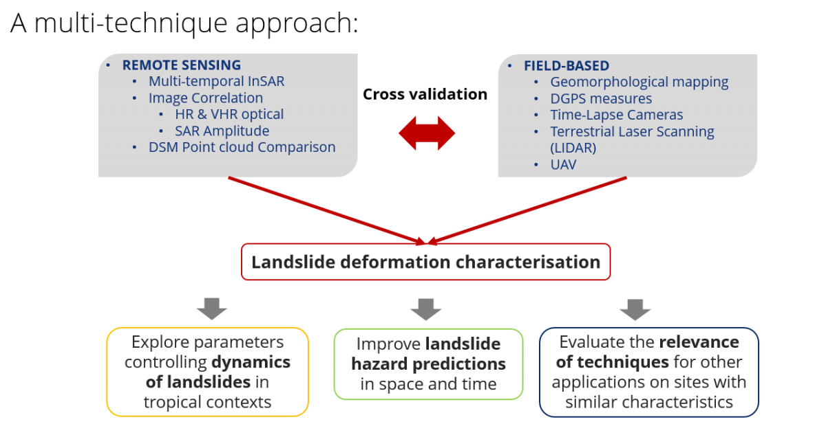
Landslides impacts are high in less developed countries, particularly in tropical areas where a combination of active tectonics, steep topography, intense rainfall and high population density is found. This is a combination that is observed in many places over the Kivu Rift (RDC, Rwanda, Burundi), the landslide-prone region where both RESIST and MODUS focus. In the framework of the mother RESIST project, the study of landslides in this region was initiated in a first approach with the aim to create a regional landslide inventory, to characterize the leading processes, and to explore the effect of rainfall on ground displacements and on landslide initiation. MODUS aims to go a step further into the characterisation of the landslides processes affecting the region, with a special focus on the city of Bukavu (DR Congo). To reach these aims, the techniques used within RESIST will be applied using additional image acquisitions allowing to extent deformation time series but these measures will, in addition, be confronted to results obtained from new techniques such as optical images correlation or terrestrial laser scanner.
The series of remote sensing techniques - ranging from ground-based close-range to spaceborne techniques - that will be employed, will, for instance, serve to the measure of the ground surface velocity fields over the area. The analysis of the latter will provide an essential piece of information to better define the parameters that are controlling the dynamics of landslides in the region, an analysis that is useful for both scientific and hazard-related purpose. To reach this goal, a multitemporal, multiscale and multi-sensor study will be built, the latter being needed to characterise the signature of distinct parameters, with various range of temporal variability and ground surface parameters.
The city of Bukavu counts currently ~800 000 inhabitants but is characterized by a rapid uncontrolled expansion. The continuously moving landslides are there responsible for a continuous degradation and destruction of houses, buildings and roads, but also of the water networks and sewerage infrastructures in several districts of the town.
The methods that will be developed in MODUS will allow a better detection and delineation of the landslides affecting Bukavu, contributing to the update of the landslide inventory that serves as a basis for the assessment of the landslide susceptibility, hazard, and risk. In the long term, these products are essential to identify suitable strategies to mitigate the negative impacts of these mass movements. The knowledge acquired with this project could thus be transposed to understand processes and develop mitigation strategies also for landslide affecting other cities of the tropics, many facing similar problematics such as slope instabilities, urban sprawl and poverty.
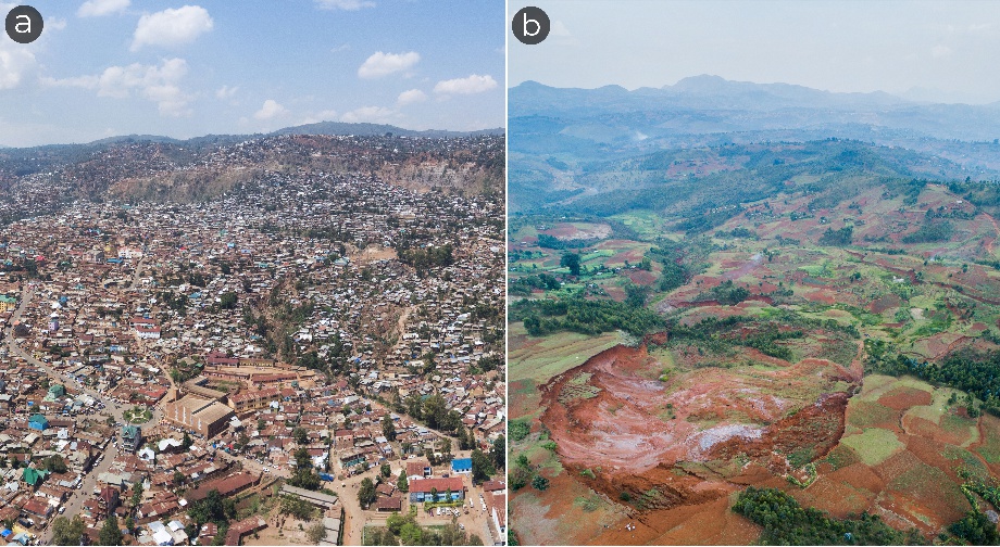
A focus is set on two key landslides (Funu (a) and Ikoma (b)) situated in the region of Bukavu. Located within 10 km of one another, the characteristics of these large, slow-moving deep-seated landslides contrast in many ways (e.g., age, degree of anthropic influence, deformation velocity, etc.), making them characteristic ‘end-members’ while sharing natural environmental conditions. By a study of their mechanisms and responses to external trigger of instability, we intend to answer the following research questions:
- What are the causes and drivers of slope instability in this tropical context? Are specific tropical conditions linked to landslide behaviour?
- Are landslides developing age-related responses to external forcings?
- Can we identify human-induced stress perturbations in their evolution?
- How do landslides evolve and how far can we predict their future behaviour?
- What are the most effective (remote sensing) methods (or combination of) to study the current (and past) dynamics of landslides in such a data-scarce context?
OBJECTIVE
MODUS aim to investigate the mechanisms of ground displacements linked to landslides in an urban-sprawling context in the tropics. The region of interest lies in the urban and peri-urban environments of the city of Bukavu situated along the Lake Kivu in DRC.
The specific objectives are:
- Estimate the surface displacement fields of the landslides and their evolution in time.
- Explore the interplay between natural (climatic and possibly seismic conditions) and human-induced parameters controlling the dynamics of the landslides in such tropical environments.
- Decipher the landslide mechanisms in order to improve hazard forecast in space and time.
To reach these specific objectives, the project deals with state-of-the-art remote sensing satellite and Unmanned Aerial Vehicles (UAV, aka drones) data, ground-based measurement techniques and a field-based landslide inventory unique for such a tropical environment and for that region in particular. An additional objective of the project is to address this landslide study from different angles and use different techniques that can in turn be better mastered for further application on other sites with similar characteristics.
STUDY AREA
MODUS aims to characterize the landslide processes affecting the city of Bukavu, in DR Congo. This city is situated on the southern shore of Lake Kivu in the western branch of the East African Rift. The city of Bukavu counts currently ~800 000 inhabitants but is characterized by a rapid uncontrolled expansion. The continuously moving landslides are there responsible for a continuous degradation and destruction of houses, buildings and roads, but also of the water networks and sewerage infrastructures in several districts of the town.
NEWS & RESULTS
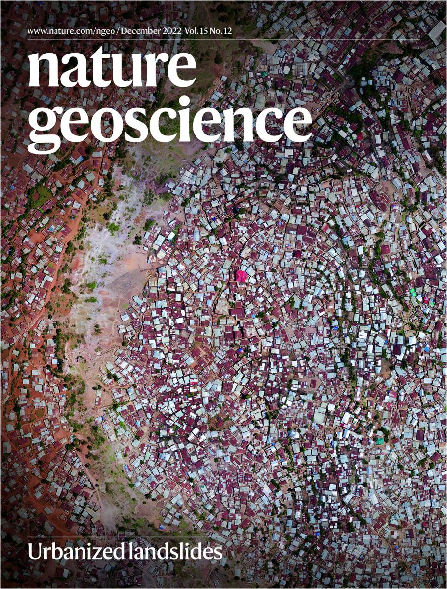
December 2022:
MODUS research made it to the cover of Nature Geoscience December 2022 issue!
November 2021:
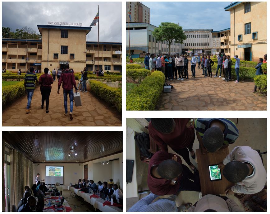
Aiming at sharing the outputs from MODUS project, we organised a 2-day workshop in Bukavu with local institutions and partners from the region (DR Congo, Uganda and Burundi). In addition, a third training course on the use of drones and photogrammetry for reconstructing surface topography took place at the Université Officielle de Bukavu!
March 2020:
Another MODUS paper is out! Check our study of the dynamics of a not-so-slow-moving landslide in tropical conditions here:
August 2019:
MODUS's first paper is out! Check our study of the causes and drivers of instability of the recent Ikoma landslide here:
June 2019:
MODUS in the spotlight! Fresh work on the recent evolution of the urban area within the city of Bukavu is presented here:
September 2018:
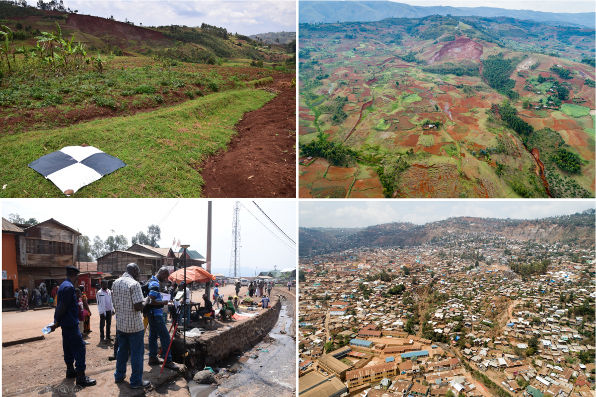
Some pictures of the 2018 field campaign. They show dGNSS campaign and GCP acquisitions for georeferencing of UAV models. Field campaigns are also used to interpret and validate the detected movements according to the environmental context directly observed.
April 2018:
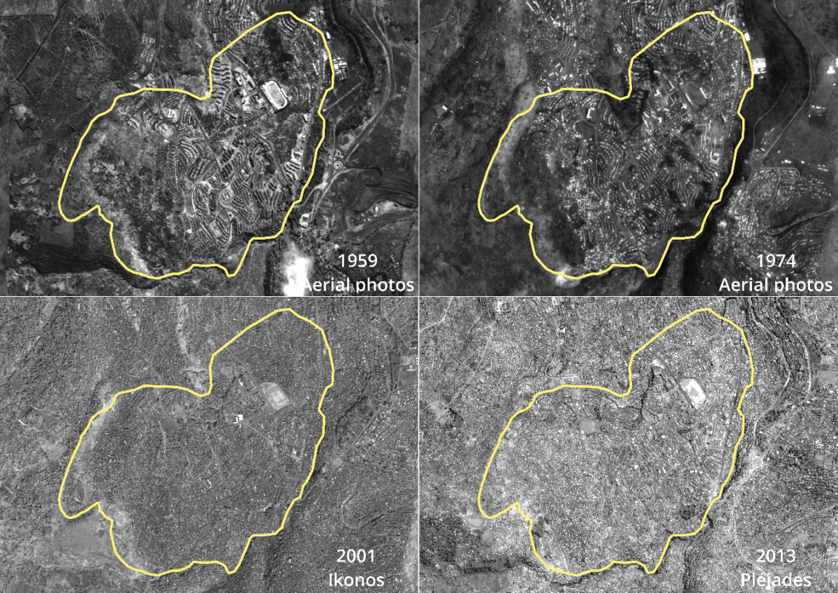
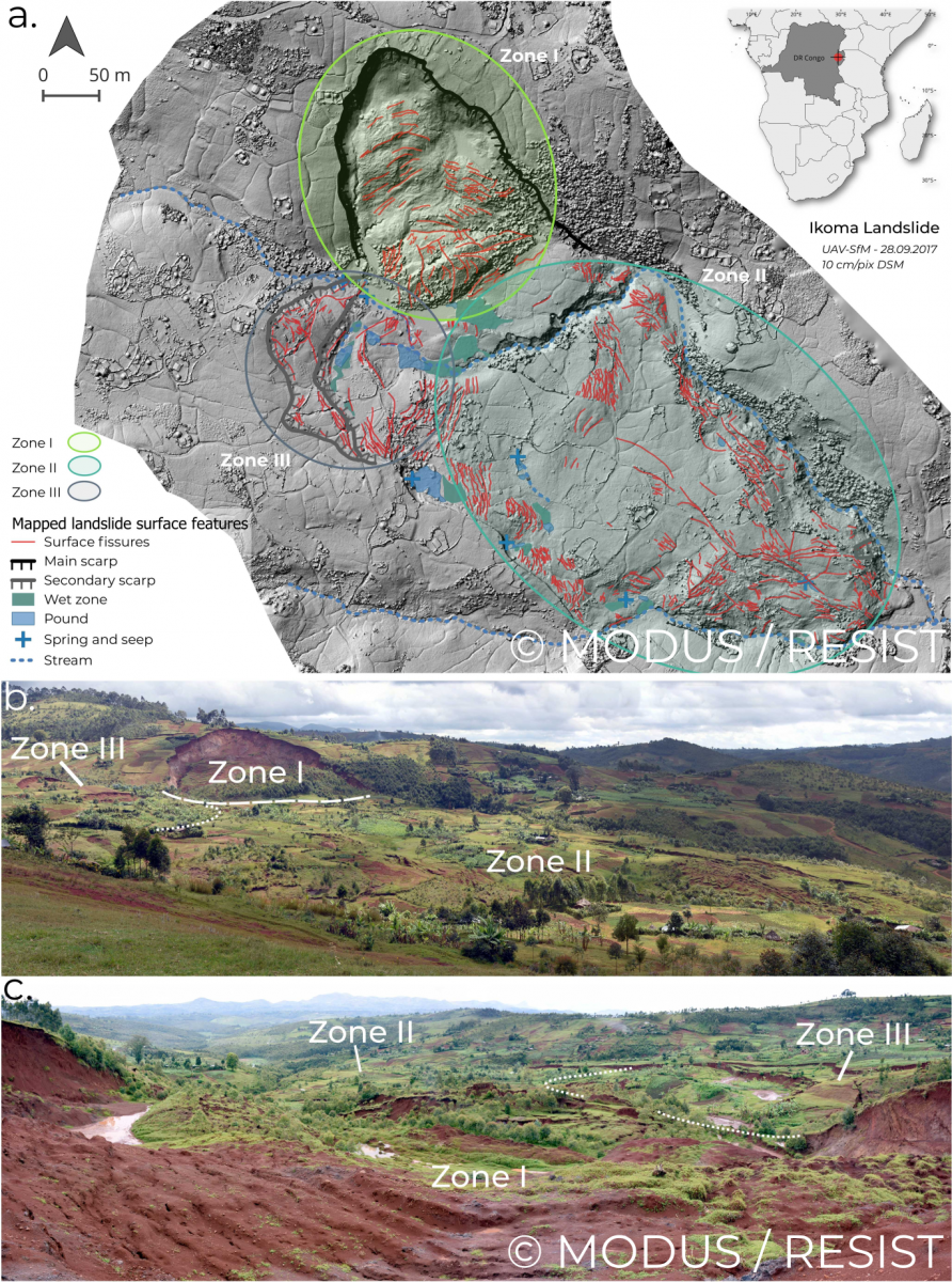
The accurate characterisation of landslide processes remains a challenge in many regions. A fundamental tool to reach this goal is the availability of high-resolution digital representation of the surface topography, which greatly facilitates the study of landslide morphology, structures and mechanisms. To this aim, we used the acquisitions from a small Unmanned Aerial Vehicle (UAV) to reconstruct the topography of a recent deep-seated landslide (called Ikoma Landslide) located near the city of Bukavu, in Eastern DR Congo. The location of this landslide in a tropical environment and within the seismically active Kivu rift, as well as the presence of recent and highly apparent surface features make it a perfect natural laboratory to study landslide processes in such a data-scarce environment.
We complemented the study of the high-resolution topography with high-resolution satellite imagery and intense field surveys, which allows us to better discriminate its spatial and temporal evolution. We mapped the landslide structures, allowing the identification of three different landslide kinematic units (Zone I, II and III on the Fig.). These different sectors highlighting interactions within the landslide body but also the occurrence of multiple deformation episodes, all providing keys for the understanding of the mechanisms and the overall behaviour of the landmass. The satellite image time-series analysis allowed for further analysis of the different failures stages, also showing that deformation features were already present more than a decade ago. Altogether, these elements provide insights into the mechanisms and behaviour of this landslide, which does not seem to have been triggered by a specific event. Information gathered in this study helping to better evaluate the landslide hazard in the particularly data-scarce Kivu Rift region.
CONSORTIUM
![]()


![]()