RESIST: Remote Sensing and In Situ Detection and Tracking of Geohazards
The RESIST project contributes to the understanding of the source mechanisms driving volcanic eruptions and
landslides in the area extending from North Tanganyika to North Virunga by:
- filling the gap of knowledge on ground-based level and;
- combining this information with innovative earth observation (EO) approaches.
RESIST exploits ground-based instrument networks, field surveys and modern EO techniques (Split Band and MSBAS InSAR time-series, SO2 flux, TRMM) to study and characterize the changes in the monitored parameters that could/should be considered as significant in terms of volcanic and landslide processes.
The project is funded by the STEREO programme of the Belgian Science Policy Office (BELSPO) and the Luxembourg National Fund for Research (FNR). The project is coordinated by the Royal Museum for Central Africa, in collaboration with the National Museum of Natural History/European Center for Geodynamics and Seismology, Centre Spatial de Liège, Belgian institute for Space Aeronomy, and NASA-Landslides.
RMCA holds a vast collection of historical aerial photographs and archives dating back as far as to the 1950's. After converting the analog photographs into a digital format, we develop land use and land cover (LULC) maps for the region between 1950 and the present. These LULC maps enable the characterization of the links between humans and land degradation processes such as landslides, deforestation, and erosion.
OBJECTIVE
RESIST aims at stepping towards the characterization of the mechanisms leading to volcanic eruptions and the detection of their precursory signals as well as landslides triggering and improving the comprehension of underlying processes.
Main objective for volcanoes
To gain scientific insights into the mechanisms that lead to an eruption and what types of measurable phenomena and signals can be robustly considered as precursory information for eruptive activity. Improved knowledge of underlying processes will also contribute to the better comprehension of continental rifting, which is found to be at an early stage in the Virunga Volcanic Province.
Main objective for landslides
To capture the temporal pattern of the landslide occurrences and to understand the importance of the climatic control on the mechanisms driving these processes. Specific attention is given to the identification of the rainfall thresholds for different landslide types and the threshold regional variability according to the processes and the environmental conditions.
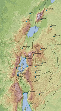
STUDY AREA
The Kivu rift area is part of the East African rift system. It is also one of the most-populated regions of Central Africa that in the meantime is exposed to a high level of geohazards.
- This region includes the Virunga Volcanic Province in eastern Democratic Republic of the Congo (DRC), western Rwanda and Burundi, as well as southwest Uganda.
- A rare combination of seismic, volcanic and landslide hazards (with highly variable recurrence rates and potential impact) in conjunction with increased demographic pressure makes Kivu particularly threatened by natural disasters.
- The source mechanisms underlying the eruptive activity of the VVP’s volcanoes as well landslide triggering and dynamics in the region of interest are still poorly understood.
RESIST study area
METHOD
RESIST combines ground- and spaceborne techniques to study two major hazards affecting the Kivu Basin region using both transversal and exclusive methods.
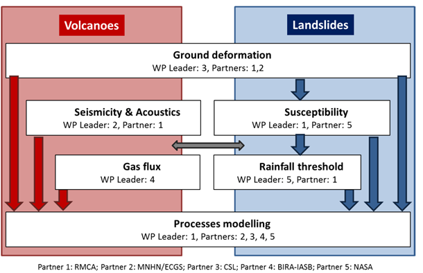
Ground deformations (transversal)
Ground deformation measurements and monitoring are achieved for both fields addressed within the RESIST project.
- Ground based methods: geodetic GPS network.
- Spaceborne methods: advanced SAR interferometry (DInSAR, SBInSAR, SBAS, MSBAS) and VHSR optical data analysis (e.g. Pleiades).
- These techniques will be complemented by field observations.
Seismic and infrasound characterization
- Installation and maintenance of the seismic and infrasound network.
- Data collection and sharing protocol.
- Signal processing of the acquired datasets.
SO2 Gas flux
- Measurements of SO2 emissions by volcanoes in the Kivu rift zone.
- Creation of a unique long-term consolidated dataset of SO2 flux for the volcanoes in Congo. This is achieved by a combination of satellite instruments (from ongoing and future missions with improved signal-to-noise and spatial resolution).
- UV camera deployed on the ground.
Landslide processes and spatiotemporal characterization
- Inventory of the landslides and the prediction of their spatial occurrence (susceptibility).
- Study of the environmental factors explaining their occurrence.
- Identification of rainfall thresholds for the different landslide types.
- Usage of TRMM (Tropical Rainfall Measuring Mission) data, and once available, the GPM (Global Precipitation Measurement) mission data.
Process modelling (transversal)
- Assessment of the physical processes and mechanisms underlying pre-eruptive activity of the volcanoes in the VVP and landslide mechanisms.
- The proper characterization of the mechanisms related to dyke intrusions and/or volcanic eruptions in the VVP will contribute to improve our understanding of the not well known continental rifting process at its early stage. The proper identification and characterization of the pre-eruptive processes can eventually contribute to the aim of eruption forecasting.
- Assessment of the landslide mechanisms in order to anticipate their future occurrence according to rainfall distribution. The different processes will be analysed according to their spatiotemporal occurrence.
CONSORTIUM
![]()


RESEARCH OUTPUTS
Videos
Renewing activity at Nyamulagira volcano
From June 22 to September 15, 2014, fountaining activity appeared in the pit crater of the Nyamulagira's summit caldera. This activity was followed, on November 1, 2014, by the emergence of a small long-lived lava lake at depth, in the pit crater. This video shows images taken on July 1 and 5, 2014, during helicopter flights and field work in the caldera.
Time-lapse video of the Nyiragongo lava lake
Time-lapse video of the Nyiragongo lava lake based of photos acquired at a 2-minutes rate, from 18 to 20 September 2011, using a Nikon D5100 camera.
Documentary on the Nyiragongo lava lake expedition
Documentary realized by the RTBF emission « Matière Grise », on a BeLux scientific expedition inside the Nyiragongo crater, in September 2011.
Scientific papers
2019
- Barrière, J., d'Oreye, N., Oth, A., Theys, N., Mashagiro, N., Subira, J., Kervyn, F., Smets, B. 2019. Seismicity and outgassing dynamics of Nyiragongo volcano. Earth and Planetary Science Letters, 528, 115821. https://doi.org/10.1016/j.epsl.2019.115821
- Theys, N., Hedelt, P., De Smedt, I., Lerot, C., Yu, H., Vlietinck, J., Pedergnana, M., Arellano, S., Galle, B., Fernandez, D., Carlito, C.J.M., Barrington, C., Taisne, B., Delgado-Granados, H., Loyola, D., Van Roozendael, M. 2019. Global monitoring of volcanic SO2 degassing with unprecedented resolution from TROPOMI onboard Sentinel-5 Precursor, Nature Scientic Reports, volume 9, Article number: 2643, https://doi.org/10.1038/s41598-019-39279-y.
2018
- Barrière, J., d'Oreye, N., Oth, A., Geirsson, H., Mashagiro, N., Johnson, J., Smets, B., Samsonov, S., Kervyn, F. 2018. Single-station seismo-acoustic monitoring of Nyiragongo’s lava lake activity (DR Congo). Frontiers in Earth Science, 6, 82.
- Jacobs, L., Dewitte, O., Poesen, J., Sekajugo, J., Nobile, A., Rossi, M., Thiery, W., Kervyn, M. 2018. Field-based landslide susceptibility assessment in a data-scarce environment: the populated areas of the Rwenzori Mountains. Nat. Hazards Earth Syst. Sci., 18 (1), 105-127.
- Kubwimana, D., Ait Brahim, L., Bousta, M., Dewitte, O., Abdelouafi, A., Bahaj, T. 2018. Landslides susceptibility assessment using AHP method in Kanyosha watershed ( Bujumbura-Burundi ): Urbanisation and management impacts. In: MATEC Web of Conferences. pp. 5.
- Monsieurs, E., Jacobs, L., Michellier, C., Basimike, J., Ganza Bamulezi, G., Kervyn, F., Maki Mateso, J.-C., Mugaruka Bibentyo, T., Kalikone Buzera C., Nahimana, L., Ndayisenga, A., Nkurunziza, P., Thiery, W., Demoulin, A., Kervyn M., Dewitte, O. 2018. Landslide inventory for hazard assessment in a data-poor context: a regional-scale approach in a tropical African environment. Landslides.
- Monsieurs, E., Jackson, T., Jean-Claude, M. M., Liesbet, J., Pierre-Denis, P., Wim, T., Umutoni, A., Musoni, D., Mugaruka Bibentyo, T., Ganza, G.B., Ilombe, G.M., Bagalwa, L., Kankurize, C., Michellier, C., Stanley, T., Kervyn, F., Kervyn, M., Demoulin, A., Dewitte, O. 2018. Evaluating TMPA rainfall over the sparsely gauged East African Rift. Journal of Hydrometeorology, 19 (9).
- Monsieurs, E., Dewitte, O., and Demoulin, A., in review 2018. A susceptibility-based rainfall threshold approach for landslide occurrence, Natural Hazards and Earth System Sciences Discussion. doi: https://doi.org/10.5194/nhess-2018-316.
- Nobile, A., Dille, A., Monsieurs, E., Basimike, J., Mugaruka Bibentyo, T., d’Oreye, N., Kervyn, F., Dewitte, O. 2018. Multi-temporal DInSAR to characterise landslide ground deformations in a tropical urban environment: focus on Bukavu (DR Congo). Remote Sensing., 10(4), 626.
2017
- Balegamire, C., Michellier, C., Muhigwa, J.-B., Delvaux, D., Imani, G., Dewitte, O., 2017. Vulnerability of buildings exposed to landslides: a spatio-temporal assessment in Bukavu (DR Congo). Geo-Eco-Trop 41, 263-278.
- Barette, F., Poppe, S., Smets, B., Benbakkar, M., Kervyn, M. 2017. Spatial variation of volcanic rock geochemistry in the Virunga Volcanic Province: Statistical analysis of an integrated database. Journal of African Earth Sciences 134, 888-903.
- Barrière, J., Oth, A., Theys, N., d’Oreye, N., Kervyn, F. 2017. Long-term monitoring of long-period seismicity and space-based SO2 observations at African lava lake volcanoes Nyiragongo and Nyamulagira (DR Congo). Geophys. Res. Lett., 44 (12).
- Delvaux, D., Mulumba, J.-L., Sebagenzi, M.N.S., Bondo, S.F., Kervyn, F., Havenith, H.-B. 2017. Seismic hazard assessment of the Kivu rift segment based on a new seismotectonic zonation model (western branch, East African Rift system). Journal of African Earth Sciences 134, 831-855.
- Geirsson H., d’Oreye N., Mashagiro N., Syauswa M., Celli G., Kadufu B., Smets B., Kervyn F. 2017. Volcanotectonic deformation in the Kivu Region, Central Africa: Results from six years of continuous GNSS observations of the Kivu Geodetic Network (KivuGNet) Journal Of African Earth Sciences,Vol. 134, 809-823
- Jacobs, L., Dewitte, O., Kabaseke, C., Kervyn, F., Maes, J., Mertens, K., Nobile, A., Sekajugo, J., Poesen, J., Samyn, D., Kervyn, M. 2017. Landslide Diversity in the Rwenzori Mountains (Uganda). In: Mikoš, M., Tiwari, B., Yin, Y., Sassa, K. (Eds.), Workshop on World Landslide Forum, Advancing Culture of Living with Landslides, Vol. 2. Sringer, Cham, pp. 79–86.
- Jacobs, L., Dewitte, O., Poesen, J., Maes, J., Mertens, K., Sekajugo, J., Kervyn, M. 2017. Landslide characteristics and spatial distribution in the Rwenzori Mountains, Uganda. Journal of African Earth Sciences 134, 917-930.
- Kalikone, B.C., Teganyi, F., Dewitte, O., Michellier, C., 2017. Ground deformation impact on the vulnerability of water and electricity distribution networks in Bukavu (DR Congo). Geo-Eco-Trop 41, 279-292.
- Ji, K.H., Stamps, D.S., Geirsson, H., Mashagiro, N., Syauswa, M., Kafudu, B., Subira, J., d’Oreye, N. 2017. Deep magma accumulation at Nyamulagira volcano in 2011 detected by GNSS observations. Journal of African Earth Sciences 134, 824-830.
- Kang Hyeun Ji, D. Sarah Stamps,Halldor Geirsson, Niche Mashagiro, Muhindo Syauswa, Josué Subira, d’Oreye N. 2017 Deep Magma Accumulation at Nyamulagira Volcano in 2011 Detected by GNSS Observations. Journal Of African Earth Sciences, Vol. 134, 824-830.
- Kervyn F., d’Oreye N. 2017. Editorial JAES AVCOR-Special Issue. Journal Of African Earth Sciences, Vol 134, 806-808.
- Kulimushi, M.S., Mugaruka, B.T., Muhindo, S.W., Michellier, C., Dewitte, O., 2017. Landslides and elements at risk in the Wesha watershed (Bukavu, DR Congo). Geo-Eco-Trop 41, 233-248.
- Libert L., Derauw D., d’Oreye N., Barbier C., Orban A. 2017. Split-Band Interferometry-Assisted Phase Unwrapping for the Phase Ambiguities Correction. Remote Sensing 9(9), 879; Spec. Iss. Advances In Sar: Sensors, Methodologies, And Applications.
- Michellier, C., Kervyn, F., Dewitte, O., 2017. From analysing geohazards to managing Georisks. In: Wymann von Dach, S., Bachmann, F., Alcántara-Ayala, I., Fuchs, S., Keiler, M., Mishra, A. & Sötz, E., (eds). Safer lives and livelihoods in mountains: Making the Sendai Framework for Disaster Risk Reduction work for sustainable mountain development. Bern, Switzerland, Centre for Development and Environment (CDE), University of Bern, with Bern Open Publishing (BOP). pp 22-23.
- Monsieurs, E., Kirschbaum, D.B., Thiery, W., van Lipzig, N., Kervyn, M., Demoulin, A., Jacobs, L., Kervyn, F., Dewitte, O., 2017. Constraints on Landslide-Climate Research Imposed by the Reality of Fieldwork in Central Africa. In: De Graff, J. V., Shakoor, A. (eds.), 3rd North American Symposium on Landslides: Landslides: Putting Experience, Knowledge, and Emerging Technologies into Practice. Association of Environmental & Engineering Geologists (AEG), 158–168.
- Mugaruka, B.T., Kulimushi, M.S., Muhindo, S.W., Dewitte, O., 2017. Anatomy of Nyakavogo landslide (Bukavu, DR Congo): interplay between natural and anthropogenic factors. Geo-Eco-Trop 41, 249-262.
- Samsonov, S., d’Oreye, N. 2017. Multidimensional Small Baseline Subset (MSBAS) for two-dimensional deformation analysis. Case study Mexico City. Canadian Journal of Remote Sensing 43 (4), 318-329.
- Samsonov, S., Feng, W. , Peltier, A., Geirsson, H., d’Oreye, N., Tiampo, K. F. 2017. Multidimensional Small Baseline Subset (MSBAS) for volcano monitoring in two dimensions: opportunities and challenges. Case study Piton de la Fournaise volcano. Journal of Volcanology and Geothermal Research 344, 121-138.
- Smets, B., d'Oreye, N., Kervyn, M., Kervyn, F. 2017. Gas piston activity of the Nyiragongo lava lake: First insights from a Stereographic Time-Lapse Camera system. Journal of African Earth Sciences 134, 874-887.
- Theys, N., De Smedt, I., Yu, H., Danckaert, T., van Gent, J., Hörmann, C., Wagner, T., Hedelt, P., Bauer, H., Romahn, F., Pedergnana, M., Loyola, D., Van Roozendael, M. 2017. Sulfur dioxide operational retrievals from TROPOMI onboard Sentinel-5 Precursor: Algorithm Theoretical Basis, Atmos. Meas. Tech., 10, 119-153.
2016
- Geirsson, H., d’Oreye, N., Mashagiro, N., Syauswa, M., Celli, G., Kadufu, B., Smets, B., Kervyn, F. 2016. Volcano-tectonic deformation in the Kivu Region, Central Africa: Results from six years of continuous GNSS observations of the Kivu Geodetic Network (KivuGNet). Journal of African Earth Sciences 134, 809-823.
- Jacobs, L., Dewitte, O., Poesen, J., Delvaux, D., Thiery, W., Kervyn, M. 2016. The Rwenzori Mountains, a landslide-prone region? Landslides 13 (3), 519-536.
- Oth, A., Barrière, J., d’Oreye, N., Mavonga, G., Subira, J., Mashagiro, N., Kadufu, B., Fiama, S., Celli, G., Birigande, JdD, Ntenge, A.J., Habonimana, L., Bakundukize, C., Kervyn F. 2016. KivuSNet: The First Dense Broadband Seismic Network for the Kivu Rift Region (Western Branch of East African Rift). Seismological Research Letters 88 (1), 49-60.
- Smets, B., Delvaux, D., Ross, K.-A., Poppe, S., Kervyn, M., d’Oreye, N., Kervyn, F. 2016. The role of inherited crustal structures and magmatism in the development of rift segments: Insights from the Kivu basin, western branch of the East African Rift Tectonophisics, 683, 62-76.
2015
- Albino, F., Smets, B., d’Oreye, N., Kervyn, F. 2015. High-resolution TanDEM-X DEM : an accurate method to estimate lava flow volumes at Nyamulagira volcano (D.R. Congo). J. Geophys. Res. Solid Earth 120, 4189 – 4207.
- Smets, B., Kervyn, M., d’Oreye, N., Kervyn, F. 2015. Spatio-temporal dynamics of eruptions in a youthful extensional setting: Insights from Nyamulagira Volcano (D.R. Congo), in the western branch of the East African Rift. J. Earth Science Review 150, 305-328.
- Syavulisemboj A., Havenithj H.-B., Smetsj B., d’Oreye, N., Marti, J. 2015. Preliminary assessment for the use of VORIS as a tool for rapid lava flow simulation at Goma Volcano Observatory, Democratic Republic of Congo. Nat. Hazards Earth Syst. Sci. 15, 2391–2400.
- Theys, N., I. De Smedt, J. van Gent, T. Danckaert, T. Wang, F. Hendrick, T. Stavrakou, S. Bauduin, L. Clarisse, C. Li, N. Krotkov, H. Yu, H. Brenot, M. Van Roozendael. 2015. Sulfur dioxide vertical column DOAS retrievals from the Ozone Monitoring Instrument: Global observations and comparison to ground-based and satellite data. J. Geophys. Res. Atmos. 120, 2470–2491.
- Wauthier, C., Cayol, V., Smets, B., d’Oreye, N., Kervyn, F. 2015. Magma Pathways and Their Interactions Inferred from InSAR and Stress Modeling at Nyamulagira Volcano. Remote Sensing 7, 15179-15202.
2014
- Brenot, H., Theys, N., Clarisse, L., van Geffen, J., van Gent, J., Van Roozendael, M., van der A, R., Hurtmans, D., Coheur, P.-F., Clerbaux, C., Valks, P., Hedelt, P., Prata, F., Rasson, O., Sievers, K., Zehner, C. 2014. Support to Aviation Control Service (SACS): an online service for near-real-time satellite monitoring of volcanic plumes, Nat. Hazards Earth Syst. Sci., 14, 1099-1123.
- Maki Mateso, J.C., Dewitte, O. 2014. Towards an inventory of landslide processes and the elements at risk on the Rift flanks West of Lake Kivu (DRC). Geo-Eco-Trop 38, 137-154.
- Samsonov, S., d’Oreye, N. ,Gonzalez, P.J., Tiampo, K. 2014. Rapidly accelerating subsidence in the Greater Vancouver region from two decades of ERS-ENVISAT-RADARSAT-2 InSAR measurements. Rem. Sens. of Env. 143 (5), 180-191.
- Samsonov, S., P.J. Gonzalez, K. Tiampo, N. d’Oreye. 2014. Modelling of fast ground subsidence observed in southern Saskatchewan (Canada) during 2008-2011. NHESS 14, 1–11.
- Smets, B., d’Orey,e N. ,Kervyn, F. 2014. Toward Another Lava Lake in the Virunga Volcanic Field?. Eos Trans. AGU 95 (42), 377-378.
- Smets, B., d’Oreye, N. , Kervyn, F., Kervyn, M., Albino, F., Arellano, S., Bagalawa, M., Balagizi, C., Carn, S., Darrah, T., Fernandez, J., Galle, B., Gonzalez, P.J., Head, E., Karume, K., Kavotha, D., Lukaya, F., Mashagiro, N., Mavonga, G., Norman, P., Osodundu, E., Pallero, J.L., Prieto, J., Samsonov, S., Syauswa, M., Tedesco, D., Tiampo, K., Wauthier, C., Yalire, M. 2014. Detailed multidisciplinary monitoring reveals pre- and co-eruptive signals at Nyamulagira volcano (North Kivu, D.R.C.). Bull. of Volc. 76 (1), 787.
- Tiampo, K.F., Samsonov, S., González, P.J., N. d’Oreye, N., Fernández J., Camacho, A. 2014. Advanced DINSAR time series analysis of natural and anthropogenic hazards. Proceedings of the IEEE International Geoscience and Remote Sensing Symposium (IGARSS).
For more information, please visit the RESIST website.
Project description also available on the AfricaMuseum website.
![]()