VeRSUS Open-Vent Volcano Remote Sensing Monitoring Using Spaceborne Imagery

The VeRSUS Project is a Spin-Off Project of RESIST, funded by the Belgian Science Policy Office (BELSPO) under the STEREO-III Programme (Contract N° SR/00/382). The project is coordinated by the Royal Museum for Central Africa (MRAC-KMMA), in collaboration with the Belgian Royal Institute for Space Aeronomy (BIRA-IASB), the European Center for Geodynamics and Seismology (ECGS, Luxembourg) and the U.S. Geological Survey (USGS, U.S.A.).
CONTEXT & OBJECTIVE
Volcanic eruptions represent a threat for populations living close to active volcanoes. Research focused on volcanic processes ultimately leading to an eruption is therefore crucial. Such research is best tackled through interdisciplinary approaches relying on the synergetic exploitation of observational datasets from ground-based instruments and satellite sensors, notably for remote and under-monitored active volcanoes. There is currently no satellite mission dedicated solely to the surveillance of volcanic activity. However, the new generation of satellites and sensors with improved sensitivity and spatial and temporal resolutions is a game-changer for volcano monitoring from space, and most remains to be done and explored.
In the mother project RESIST (2014-2019, STEREO-III Programme), we developed new remote sensing tools that were used to study the eruptive activity of the Virunga volcanoes (Eastern D.R. Congo). Results showed promising perspective to further study persistent lava lakes using satellite remote sensing, especially with the new generations of satellites and sensors. In the VeRSUS project, we would like to take advantage of these opened perspectives and complement them with other volcano remote sensing approaches, in order to improve the study of persistent lava lakes and, hence, crustal magmatic processes.
Specific objectives
- Exploring and developing the capacity of new satellites sensors to provide complementary quantitative information on the dynamics of persistent lava lakes.
- Getting a better understanding of the source mechanisms of variations in the lava lake activity.
STUDY AREA
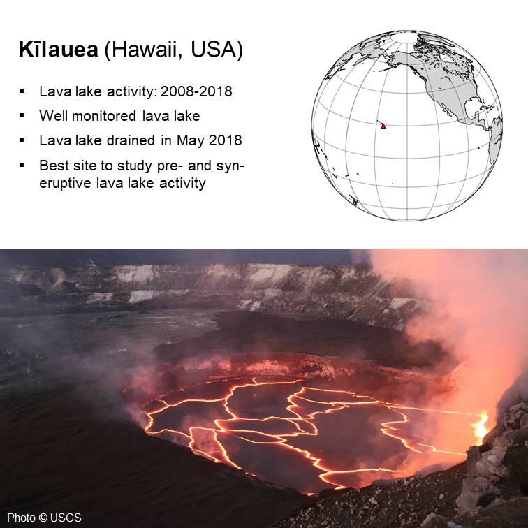
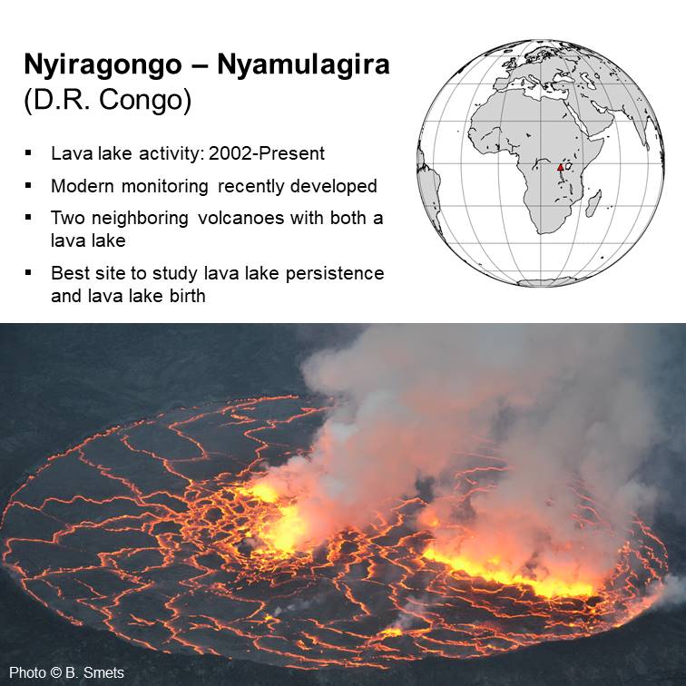
Two test site were selected to perform the tasks planned in VeRSUS
METHODOLOGY
In VeRSUS, we would like to take advantage of the new developments of the mother project RESIST and the perspectives they offer, by implementing all the main existing volcano remote sensing techniques to the new generation of satellite images, in order to study the dynamics of persistent lava lakes. Hence, we will combine SAR interferometry, innovative SAR-shadow lava lake level measurements, thermal remote sensing using different types of satellites, SO2 gas flux estimates using the new TROPOMI sensor on-board Sentinel-5 Precursor, and daily to weekly observation using the new generations of high spatial resolution optical satellites. Results from remote sensing will be cross-correlated with ground-based measurements in order to improve the interpretation of the lava lake activity.
In terms of satellite imagery, we will primarily use the imagery currently available at no-/low-cost for scientific research, such as the ESA Copernicus Sentinel constellations, as well as Suomi NPP VIIRS, Landsat 8 OLI, PlanetScope, Pléiades and COSMO-SkyMed data.
.
CONSORTIUM
![]()
.jpeg)
![]()