LACTOSE
Slow-moving LAndslides in Changing TrOpical landscapes: dynamics and hillslope connectivity from SpacE
The LACTOSE project (2023-2026) aims to quantify at the regional scale how natural and human-induced environmental conditions control the dynamics of slow-moving landslides (SML) and their sediment contribution to river systems in changing tropical landscapes. Overall, this work aims to move forward our understanding of a key geomorphic process in a severely under-researched environment subjected to rapid changes. This is not only essential for a better hazard assessment, but also for comprehending how (human-induced and/or natural) environmental changes affect tropical landscapes and their sediment dynamics.
![]()
LACTOSE will work at the regional scale by exploiting synergies between different space-borne remote sensing tools (optical and radar imagery, historical aerial photographs, etc.). It is at the crossroads between natural hazard assessment, geomorphology, land degradation, sediment dynamics, and environmental changes with, at its heart, Earth Observation. It is strongly framed around synergies, long-term collaborations, knowledge-transfer, and capacity-building actions with several key research institutions in Africa.
This 3-year project is funded by the Belgian Science Policy Office (BELSPO) under the STEREO IV programme (Contract SR/00/403) and is coordinated by the Royal Museum for Central Africa (Antoine Dille, Olivier Dewitte), in collaboration with the Vrije Universiteit Brussels (Benoît Smets) and the KU Leuven (Matthias Vanmaercke).
Context & objectives
Human activities transform Earth ecosystems and landscapes at unprecedented rates and scales. Land use changes are particularly drastic in economically developing countries of the tropics, where major demographic/economic shifts are driving unparalleled rates of agricultural expansion, deforestation and urbanisation. These changes to the environment are increasing the incidence of geo-hydrological hazards such as landslides. Dramatic increase in the occurrence of shallow, high-velocity landslides has been comprehensively demonstrated on recently deforested and/or urbanised steep slopes. Yet, our understanding of natural and human-induced controls on large, slow-moving (mm year−1 to 100 m year−1), deep-seated landslides (SML) remains much more limited. Often manifesting as long-term, persistent slope failures, these SML however frequently and permanently affect the livelihood of local communities in mountain regions.
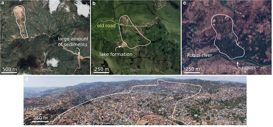
These SML were the focus of the STEREO III project MODUS; i.e. the mother project of LACTOSE. By exploiting and developing state-of-the-art radar and optical remote sensing data and methods, combined with space- and airborne photogrammetry, MODUS showed that Earth Observation data available today offer unique opportunities to accurately quantify and monitor SML at any place around the globe – i.e., even in remote, under-researched tropical environments – over both short and decadal time scales (Dille et al., 2019, 2021, 2022). Thanks to this, MODUS demonstrated for the first time the singularity of the climatic, lithological and tectonic causes and triggers of slope instability in tropical environments. It also allowed to show for the first time that urbanisation can influence the behaviour of long-lived and large SML. Yet, while MODUS provided unprecedented insights on key aspects of our comprehension of Earth surface processes and of the interactions between human and landscapes, its focus was only on two representative SML; which remains too limited to really draw robust conclusions on the highlighted natural and human-induced processes.
In LACTOSE, our research hypothesis is that to further unravel the fundamental but intricate influences of climate, lithology, tectonics and man-made environmental changes on the activity of SML emphasized in MODUS, a change in scale is required; moving from the two landslides studied to possibly hundreds that spread across diverse landscape and climate conditions. Building on the learnings and methodological development from MODUS, and capitalising on the new possibilities offered by cloud computing, we aim in LACTOSE at providing a first large-scale assessment of the presence and dynamics of active SML and their spatial variations across a large spectrum of natural and human-impacted landscapes in tropical climates. Hence, our first key research question is to quantify how natural and human-induced tropical environmental conditions controls the occurrence and dynamics of SML.
We also hypothesize that gathering such a large datasets of the activity of SML across diverse landscape and climatic conditions would also allow to investigate the contribution of SML to regional sediment fluxes. Indeed, the long-term, persistent motion of SML also place them as a major geomorphic process in mountain landscapes – they shape the morphology of hillslopes, exert very strong controls on river sediment budgets and flooding patterns, etc.. Yet, while recent research tend to show that large SML exert a primary influence on regional sediment fluxes, observations and analysis of SML impact on regional erosion and river sediment loads are very scarce. Better constraining the contribution and controlling factors of SML to contemporary sediment fluxes is key for our understanding of landscapes, sediment budgets and geo-hydrological hazards, and is the second research question we aim to address with the LACTOSE project.
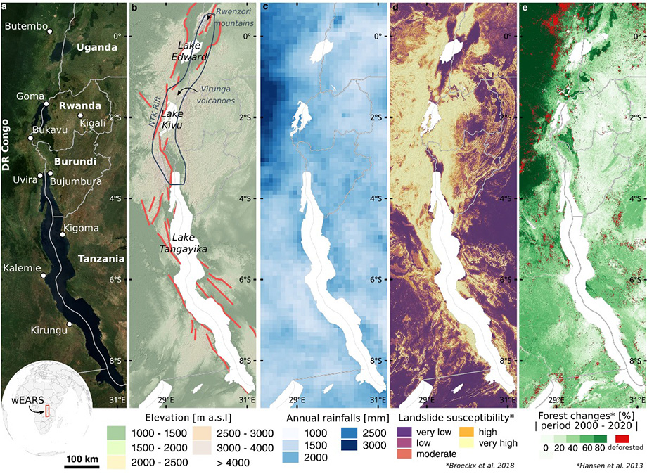
To answer these two open research questions, we aim at exploiting synergies between different space-borne remote sensing tools (optical and radar imagery, historical aerial photographs, etc.) to analyse SML processes across the diverse landscape conditions of the western branch of the East African Rift System (wEARS). The wEARS is indeed exemplative of many tropical mountain regions, i.e., affected by large-scale land use changes and disproportionately high landslide impacts. Overall, this work will significantly move forward our understanding of a key geomorphic process in a severely under-researched region subjected to rapid environmental changes. This is not only essential for a better hazard assessment, but also for comprehending how (human-induced and/or natural) environmental changes affect these landscapes and the sediment dynamics.
The SPECIFIC SCIENTIFIC OBJECTIVES (SO) of the project are:
- SO1: To present a first large-scale assessment of the presence of active SML and their spatial variations across a large spectrum of landscape conditions.
- SO2: To quantify and untangle the respective influences of natural (climate, lithology, tectonic settings, etc.) and human-induced (expansion of cultivated and urban land, deforestation) controls on the past and present dynamics of SML.
- SO3: To quantify the potential contribution of SML to river sediment loads by studying their dynamics and connectivity.
Study area
A fundamental challenge is to be able to disentangle the baseline dynamics of the SML processes, i.e. the rates and patterns that would occur under natural conditions (in terms of geophysical, biophysical, and climatic conditions). For this, the project will rely on state-of-the-art remote sensing approaches to acquire a large set of measurements on SML motion from a wide variety of tropical environmental conditions and spatio-temporal scales. The western branch of the East African Rift System (wEARS) will be used as area of interest. It is characterised by a very large natural landscape diversity shaped by a strong north–south climate gradient, active continental rifting, and contrasting histories of human occupation. The wEARS is also ideal because representative for many tropical mountain regions, i.e., i) affected by rapid, large-scale landscape transformations associated with agricultural expansion and urbanisation, ii) disproportionately impacted by landslides, and iii) largely overlooked in landslide research.
Methods
This project will adapt and develop innovative tools and approaches in space Earth observation to study the rates and controls on SML dynamics over a regional scale. The remote sensing methodology is built upon the proofs of concept developed in MODUS – the mother project of LACTOSE – and will rely on two key tools: Synthetic Aperture Radar interferometry (InSAR) and sub-pixel image correlation.
Multi-temporal InSAR is particularly suited for the study of landslides moving with velocities ranging from a few cm to a few dm per year. Being able to provide mm-accuracy measurements of deformations at high spatio-temporal resolutions and being independent from sun illumination and cloud cover, it is a method that has greatly improved the understanding of landslide mechanisms and dynamics. We will exploit the high revisit capabilities of ESA C-band Sentinel-1 to measure deformation processes in zones with low vegetation cover (e.g., in urban area). To further increase our spatial coverage in rural and forested areas, we will in addition use data from the L-band JAXA ALOS-2, NASA-ISRO SAR (NISAR) and SAOCOM. In the continuity of the work carried in MODUS, we will take advantage of the robust and versatile “InSAR Mass processing Toolbox for multidimensional Time series” (MasTer) for processing radar images. MasTer is an in-house tool developed in partnership with Centre Spatial de Liège (Belgium) and the NMNH/ECGS (Luxembourg) partially in the framework of STEREO III projects (namely RESIST, MUZUBI and MODUS). It is a fully automatic, unsupervised processing chain based on the multidimensional small baseline subset (MSBAS) method that has already been tested and used for studying landslides in wEARS and which last iterations are specifically designed for the processing of large SAR datasets.
When landslides are too fast for InSAR, sub-pixel image correlation (also sometimes referred to as offset tracking) is now a common technique to measure deformation patterns. Recently, authors started to make use of time series inversion approaches that are similar to those applied to multi-temporal InSAR. This allows to greatly enhance signal-to-noise ratio and overall, greatly improves the ability to identify active surface processes. We will take advantage of the high temporal sampling of recent sensors by applying a combination of sub-pixel image correlation and time-series inversion on optical satellite images (Sentinel-2, Landsat 8 and Landsat 9) and radar-amplitude images (Sentinel-1). We have demonstrated within MODUS how integrating deformation maps and exploiting synergies between sensors is a game changer for acquiring accurate, high spatial and temporal resolution measurements of landslide motions in tropical contexts. This combination was for instance key to circumvent constraints brought by i) the persistent cloud cover and rapid vegetation growth associated with tropical climates, or ii) the large ranges of potential landslide velocities (from a few cm yr-1) to dozens of m yr-1).
Untangling the intricate influences of climate, lithology, tectonics and man-made environmental changes on the activity of SML over the wEARS will require a large and robust dataset across diverse landscape conditions. This regional scale also calls for the use of cloud computing infrastructures. We will use different platforms (e.g., ESA Geohazards Exploitation Platform, the Belgian VITO Terrascope platform, CREODIAS) depending on the proposed flexibility, needs and the remote sensing products considered, also aiming to avoid a major dependency on a single commercial platform (e.g., Google Earth Engine whose flexibility for SAR processing is limited). With approaches based on freely-available datasets, tools and computing infrastructures, we foster data and method exchange, and aim at making the results available for a broad community of users. This will notably ease dissemination in Africa. In doing so, this project is strongly embedded in recent international DRR priorities that concern the development and dissemination of science-based methodologies and tools to record and share disaster losses and disaggregated data and statistics.
Some references on which the project is built:
- Dille, A., Dewitte, O., Handwerger, A.L., d’Oreye, N., Derauw, D., Ganza Bamulezi, G., Ilombe Mawe, G., Michellier, C., Moeyersons, J., Monsieurs, E. and Mugaruka Bibentyo, T., 2022. Acceleration of a large deep-seated tropical landslide due to urbanization feedbacks. Nature Geoscience, pp.1-8.
- Dille, A., Kervyn, F., Handwerger, A.L., d'Oreye, N., Derauw, D., Bibentyo, T.M., Samsonov, S., Malet, J.P., Kervyn, M. and Dewitte, O., 2021. When image correlation is needed: Unravelling the complex dynamics of a slow-moving landslide in the tropics with dense radar and optical time series. Remote Sensing of Environment, 258, p.112402.
- Depicker, A., Jacobs, L., Mboga, N., Smets, B., Van Rompaey, A., Lennert, M., Wolff, E., Kervyn, F., Michellier, C., Dewitte, O. and Govers, G., 2021. Historical dynamics of landslide risk from population and forest-cover changes in the Kivu Rift. Nature Sustainability, 4(11), pp.965-974.
- Dewitte, O., Dille, A., Depicker, A., Kubwimana, D., Maki Mateso, J.C., Mugaruka Bibentyo, T., Uwihirwe, J. and Monsieurs, E., 2021. Constraining landslide timing in a data-scarce context: from recent to very old processes in the tropical environment of the North Tanganyika-Kivu Rift region. Landslides, 18(1), pp.161-177.
Consortium
![]()
![]()
![]()
![]()