MODUS: A Multi-sensOr approach to characterize ground Displacements in Urban Sprawling contexts
Landslides impacts are high in less developed countries, particularly in tropical areas such as the Kivu Rift (DRC, Rwanda, Burundi) where a combination of active tectonics, steep topography, intense rainfall and high population density is found. In the framework of the RESIST project, the study of landslides in this region was initiated with the aim to create a regional landslide inventory and to characterize the leading processes, with a focus on the effect of rainfall. MODUS aims to go a step further, with a special focus on the urban-sprawling city of Bukavu (DRC). A series of remote sensing techniques are employed, allowing among others unprecedented long time-series and quantification of ground surface deformations; this being the key for a better understanding of the landslide mechanisms and an improvement of the assessment of the related hazards.
The project is funded by the STEREO programme of the Belgian Science Policy Office (BELSPO) and coordinated by the Royal Museum for Central Africa, in collaboration with the Centre Spatial de Liège et l'Ecole et Observatoire des Sciences de la Terre in Strasbourg.
For more information about VeRSUS, please visit the MODUS webpage.
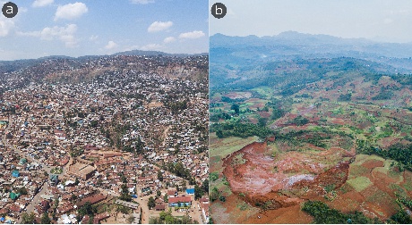
Funu (a) and Ikoma (b) landslides, two large, slow-moving landslides sited in the Kivu Rift (DRC). Funu is a thousand-year-old, 1.5 km², deep-seated landslide located within the densely inhabited city of Bukavu (South Kivu). It is estimated that about ~80,000 people live on the landslide, that in continuously moving at rates of 0.1-3m/yr. Ikoma landslide (0.2 km²) is more recent (first signs of instability documented in the ‘50s) and sited in the rural surroundings of the city of Bukavu. Within MODUS, our aim is to study the mechanisms and dynamics of such landslides over the last decades to better understand the hazard they pose to the population and how different they are from their temperate counterparts. Both pictures taken from UAS in Oct. 2018 (A. Dille).
![]()