GEOTROP: GEOmorphic hazards and compound events in a changing TROPical East Africa
The GEOTROP-project (2022-2025) aims to assess the role of land-use change and climate change in the occurrence of geomorphological hazards (landslides and flash floods) in tropical East Africa. In addition to analysing the current situation, we will also study the potential effects of human-induced changes in climate and land use/land cover on the occurrence of extreme events in the future and the associated risks.
This three-year project is funded by the Belgian Science Policy Office (BELSPO) under the BRAIN-be 2.0 programme (Contract No. B2/223/P1/GEOTROP). The project is coordinated by the Royal Museum for Central Africa (KMMA), in collaboration with the Vrije Universiteit Brussel (VUB), the European Centre for Geodynamics and Seismology (ECGS), the National Museum of Natural History (NMNH), the École et Observatoire des Sciences de la Terre (EOST), the Centre national de la recherche scientifique (CNRS) and the Helmholtz Centre for Environmental Research (UFZ).
CONTEXT & OBJECTIVES
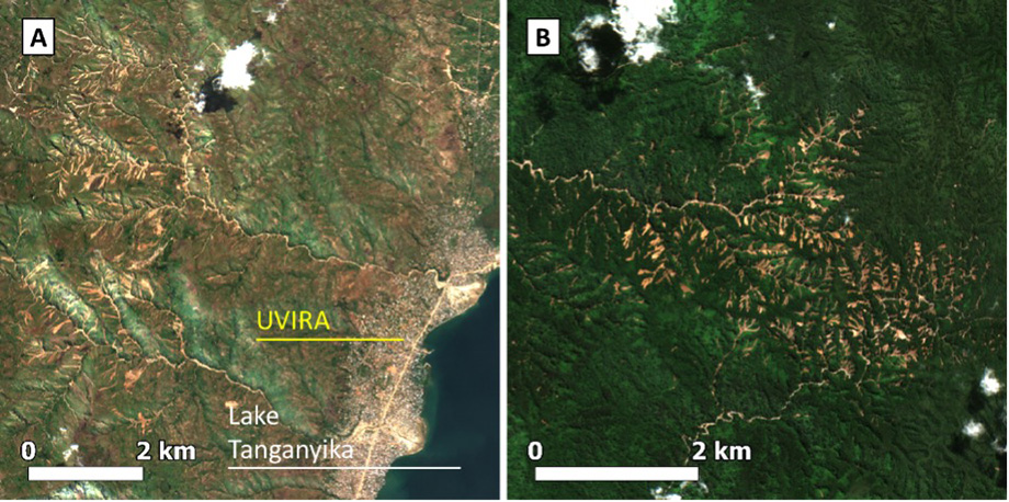
Landslides and flash floods are geomorphological hazards (GH) that are often the result of a combination of interacting processes at multiple scales (both spatially and temporally). GH events are linked to climatic factors (e.g. rainfall intensity) and landscape factors (e.g. vegetation patterns). Landscape transformation, such as deforestation, has consequences for GH events, and climate change will alter many climate factors.
The tropics are environments where GG have not yet been sufficiently studied. Tropical mountainous regions are also characterised by high and increasing population densities coupled with high social vulnerability. GG events have a disproportionate impact on these regions. In the future, the frequency and/or consequences of geological hazards will be more severe; not only due to factors such as climate change and deforestation, but also due to population growth and increased exposure to these disasters.
In many cases, landslides and flash floods occur very rapidly. Landslides and flash floods often occur together and interact with one another, leading to events with even more severe consequences. The combination of various processes (climatic factors and/or hazards) that result in a significant impact is referred to as a ‘compound event’. Although it can be assumed that many geological hazards can be regarded as compound events, the understanding, analysis, quantification and prediction of such events are still in their infancy, particularly at regional level.
GEOTROP aims to analyse the role of land-use change and climate change in the occurrence of compound geological hazard events in tropical East Africa.
The specific objectives (SO) are:
- SO1: To develop an unprecedented regional inventory of GG events;
- SO2: To understand the spatial distribution of GG events across the landscape and the role of land-use change in their occurrence (location of GG events);
- SO3: To uncover the interaction of multiple landscape and climate factors in triggering GG compound events (timing of GG events);
- SO4: To project the future evolution of GG compound events, so that future hazards and risk hotspots can be identified.
In addition to these four SOs, GEOTROP also aims to strengthen the capacities of African institutions involved in disaster risk reduction.
STUDY AREA
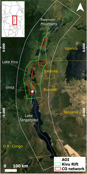
GEOTROP’s study area is the western branch of the East African Rift; a mountainous region characterised by a wide range of tropical climates and environmental conditions. In addition to its natural landscape diversity, this study area is characterised by a mix of contrasting pristine and heavily human-modified landscapes. A thorough understanding of the study area is key to the project’s success and makes it the ideal location for our research, given that it is:
- A global biodiversity hotspot due to particularly favourable environmental conditions. Despite recent research led by the RMCA in the study area, significant research gaps remain regarding the understanding of climate and landscape factors affecting biodiversity at a regional level;
- A strong north-south climate gradient associated with the dynamics of the Intertropical Convergence Zone (ITCZ) and driven by climate fluctuations in the Indian Ocean Dipole (IOD) and ENSO, which contribute to a frequent succession of extremely dry and wet periods;
- A climate change hotspot with expected changes in both temperature and average and extreme precipitation patterns;
- A tropical environment characterised by uncontrolled urbanisation and deforestation;
- Diverse landscapes where the soil and climate are highly conducive to the expansion of agriculture;
- A high population density (often > 300 inhabitants/km²) that is increasing, high vulnerability and a strong societal need to understand climate and hazard processes at the border between six countries;
- Unique long-term expertise in the region held by the KMMA and its partners.
METHODS
In GEOTROP, the use of satellites will make it possible to determine the time and location of GG events with high accuracy on a regional scale. As cloudy conditions are ubiquitous in our tropical study area, the location and time of the GG event will be determined using a combination of optical and radar satellites. The analysis of the detected GG events will be carried out using satellite measurements and harmonised climate and land-use/landscape-change models. GEOTROP relies on high-performance computing and cloud computing infrastructures to process these very large datasets. Information from the public will be used to validate the methods and to gain a better understanding of the underlying processes.
This project will improve our understanding of natural hazards in the context of global change in under-researched climates. It is innovative in terms of developing better hazard zoning and DRR strategies in the region, as well as in gaining a better understanding of the evolution of landscapes and the associated hazards. The project combines innovative methods in Earth observation and climate science to operate on an unprecedented large regional scale.
ONDERZOEKS RESULTATEN
Data
- GH event inventory from Deijns et al. 2022 NHESS Timing landslide and flash flood events from SAR satellite - https://doi.org/10.5281/zenodo.7198322, 2022b.
Scripts
- Python scripts for GH event timing estimation from Sentinel-2 SAR data used from Deijns et al. 2022 NHESS Timing landslide and flash flood events from SAR satellite - https://doi.org/10.5281/zenodo.7198346, 2022a.
Wetenschappelijke artikelen
- Deijns, A. A. J., Dewitte, O., Thiery, W., d'Oreye, N., Malet, J.-P., and Kervyn, F.: Timing landslide and flash flood events from SAR satellite: a regionally applicable methodology illustrated in African cloud-covered tropical environments, Nat. Hazards Earth Syst. Sci., 22, 3679–3700, https://doi.org/10.5194/nhess-22-3679-2022, 2022.
CONSORTIUM