GeoKivu project

GeoKivu is a project funded by the Belgian Directorate-General for Development Cooperation and Humanitarian Aid (DGD). This project aims to safeguard and valorise the archives of the Royal Museum for Central Africa (RMCA) and partner institutions in Kivu. The geolocatable archives of these institutions (maps, reports, memoirs, etc.) are inventoried and encoded in a geocatalogue of metadata that can be consulted online. As part of the reinforcement of the partners' expertise, each institution develops a specific GIS application with the objective of enriching regional and local knowledge in different fields (earth sciences, geography, zoology).
GeoKivu was born out of the many exchanges that the Royal Museum for Central Africa has with Congolese partner institutions in the provinces of North and South Kivu. These collaborations, established since 2012, have already had important scientific spin-offs in the framework of applied scientific research projects (GeoRisCA, RESIST, virungas-volcanoes, etc.), or scientific cooperation and expertise development (for example S1-RGL-GEORISK).
From these different activities, the need to address the valorisation of the documentary collections concerning Kivu and present both in these Congolese institutions and at the RMCA has gradually emerged.
THE APPLICATIONS
-
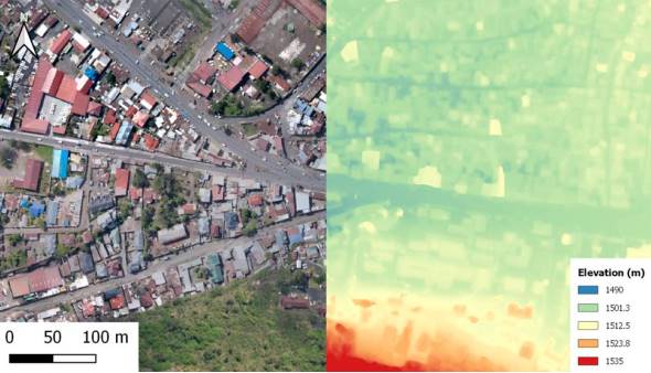
Mapping the city of Goma
In Goma, the acquisition of digital information in cartographic format by the Institut Géographique du Congo (IGC) is a real advance in terms of the quality of the data currently available. These data are acquired and processed according to scientific methodologies and rigour and are intended to serve as a reference for the many users (NGOs, UN agencies, public institutions) who often produce their own data for their own purposes. Through this specific application, the IGC's ambition is to develop a set of quality data, homogeneous and accessible to users who wish to develop better documented projects.
-
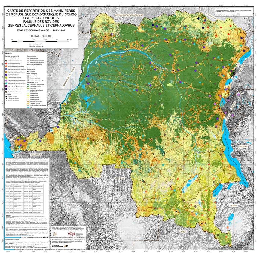
Distribution maps of mammal species in DRC
At the Centre de Recherche en Sciences Naturelles (CRSN) in Lwiro, the GEOKIVU team is working on several distribution maps of different mammal species in the DRC based on the CRSN archives. In addition to safeguarding information endangered by difficult conservation conditions, they also provide an unprecedented look into the past and the basis for possible new scientific research on the mammal species of the DRC.
-
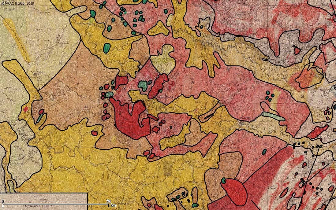
The geological map of Kivu
The Official University of Bukavu (UOB) is working on the first regional geological map of Kivu. This map is the result of the compilation of archival data from different sources, collected during field campaigns, the oldest of which date back to the first half of the 20th century. This synthesis work is crucial in the regional knowledge of geology and complements the work carried out by the RMCA in Rwanda and Burundi. Better knowledge of the geology and the development of new tools for better knowledge and therefore management of resources is essential for the development of the eastern DRC.
-
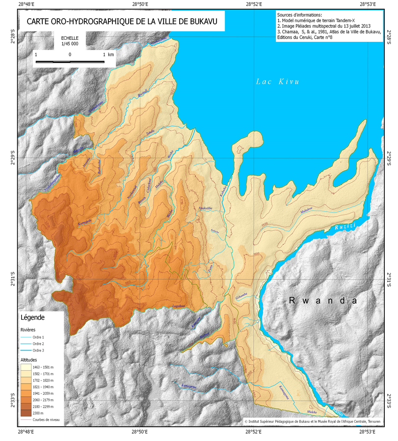
The Bukavu atlas
The development of the Bukavu atlas by the Institut Supérieur Pédagogique (ISP) responds to the need to update knowledge of this city, which has expanded extremely rapidly and significantly since the previous atlas was produced in 1981. This work involves Congolese and Belgian geographers. The atlas should serve as a reference for secondary schools, university institutions and the various state services that manage the urban territory of Bukavu. So far, the atlas has not be finalised.
THE GEOCATALOGUE
The geocatalogue was developed within the framework of GeoKivu. It presents the metadata of several thousand documents archived in the partner institutions (ISP, UOB, CRSN, IGC, MRAC). This geocatalogue is currently in the development phase and receives frequent updates.
==> To the Geocatalogue webpage
CONSORTIUM
For more information, please visit the GeoKivu website.
Project description also available on the AfricaMuseum website.
![]()