PAStECA: Historical Aerial Photographs and Archives to Assess Environmental Changes in Central Africa

The study area of the PAStECA project (2017-2021) encompasses the western branch of the East African rift system (East DRC, Rwanda, Burundi), a region with a rapidly growing population. Despite the sometimes devastating impact of humans on their environment, the interactions between demography, land use and land cover change, and land degradation in the region remain mainly unstudied. A limiting factor of such research is the lack of historical data records.
RMCA holds a vast collection of historical aerial photographs and archives dating back as far as to the 1950's. After converting the analog photographs into a digital format, we develop land use and land cover (LULC) maps for the region between 1950 and the present. These LULC maps enable the characterization of the links between humans and land degradation processes such as landslides, deforestation, and erosion.
At the same time, the results of PAStECA serve as an indicator of how useful these archives are in the context of modern scientific research. They will clarify whether the investment in digitizing the historical aerial photographs is justified within the context of research.
OBJECTIVE
The conversion of natural lands into human-dominated landscapes, through for instance urban sprawl or agriculture expansion, is a major component of global environmental change. These human-induced transformations of environments can have impacts for example on biodiversity, climate and land surface feedbacks, and soil and landscape degradation. Alongside these changes, land cover modifications also alter ecosystem services. Assessing the processes of land use and land cover (LULC) changes and possible future scenarios is of paramount importance if we are to embed sustainability in development strategies, ecosystem management, and land use planning, particularly for developing countries where rates of LULC changes are highest.
To quantify and understand the complexity of changes and subtle modifications in LULC, an accurate account of past LULC conditions and recent changes over a multidecadal time scale has an important added value. Indeed, the documentation of long-term trajectories of LULC change can yield important new insights because of the importance of some of the drivers of LULC change, such as demographic growth and rural-urban migration, only becomes apparent over sufficiently long time spans, and the relative importance of drivers of LULC change changes significantly over such timescales.
However, sufficiently long, multidecadal records of LULC changes are almost inexistent for the least developed areas of the globe. This important lack is not easy to fill: global and regional LULC assessments derived from the first satellite data from the 70s and 80s offer a spatial resolution that is often too coarse for this purpose and the very high-resolution satellite data became available only at the end of the 90s at best. The use of historical black and white aerial photographs offers the possibility of studying a longer time frame. Such photos show excellent spatial details that make them appropriate for studying, for instance, topics as different as forest transition, landslide dynamics, soil erosion and urban sprawl.
The general objective of the PAStECA project is to evidence the importance and the added value of archive documents in studies addressing present-day issues in areas lacking baseline studies. In the present case, aerial photographs and archives from RMCA will support present-day environmental change studies in target tropical environments of Central Africa. The focus of the environmental topics relies on the spatio-temporal dynamics of LULC changes. The project deals with land occupation and demography, land degradation, slope processes and geohazards issues.
- The first specific objective is to produce geolocalised digital products of the historical photographs and archives that can be used for LULC studies in general.
- The second specific objective of this project is to explore the causes, impacts, scales, and trends of the LULC and its changes in the context of environmental degradation with the help of these digital products.
- The third specific objective is dedicated to improving the accessibility of digital products related to historical photographs, archives and LULC changes available for both the international scientific community and the public at large to foster their exploitation.
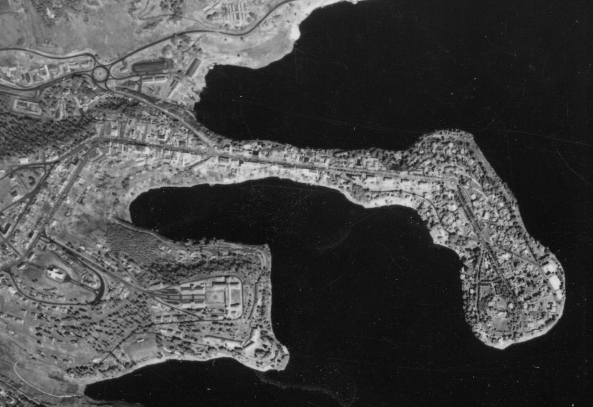
Bukavu in 1959
STUDY AREA
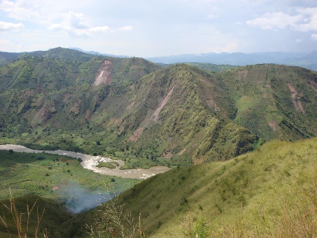
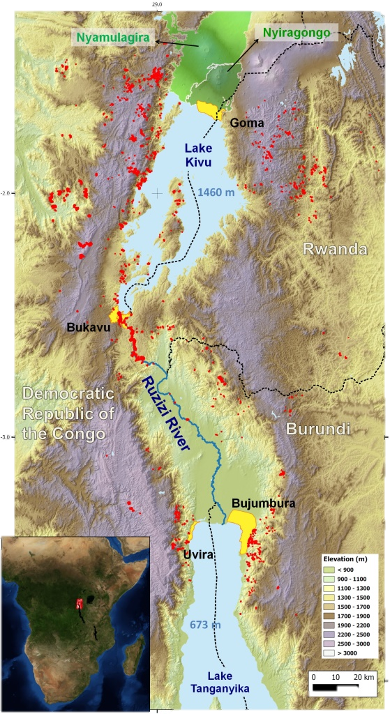
The study area is confined to the tropical mountain environments of the western branch of the East African Rift. This region from the North Tanganyika rift zone in the south to the Virunga Volcanic Province in the north. Its LULC evolution is very interesting to study because of the combination of the following natural and human characteristics:
- The area has one of the highest population densities of Africa, urban expansion is very fast and anthropogenic pressure high (e.g., in Rwanda, the population density raised from 183 inh./km2 in 1978 to 415 inh./km2 in 2012 whereas the density for the whole continent is only of 39 inh./km2). Bukavu, Bujumbura, and Goma are cities with a current population of approximately 800,000 each, while in the colonial period, only a few thousands lived in these cities. That population increase as a drastic effect in urban areas but also in rural areas where land conflicts are a real issue;
- A large majority of the population relies on agriculture;
- A significant part of the population is directly or indirectly related to the mining sector and both are contributing to land degradation;
- The area is at the border between three countries (with different governance policies and socioeconomic characteristics);
- Landscape is diverse (mountains, lakes, rivers, volcanoes) and soil and climate are very favorable for agriculture expansion;
- The area is affected by years of conflicts that in turn are jeopardizing the socio-economic development and impacting LULC (migration, land pressure on natural parks, mine control);
- Natural triggering and predisposing factors such as heavy rainfall, tectonic activity, and steep topography favor the occurrence of landslides and soil erosion processes (included large gullying). In addition, Nyamulagira and Nyiragongo are two very active volcanoes and a source of various hazards (lava flow, toxic gas release). The volcanic risk and the lava flows, in particular, are adding more pressure on land use planning in the region of Goma;
- RMCA has developed a very strong expertise on the region over the last decade and has collected unprecedented datasets for similar environments;
- RMCA and ULB have developed a large network involving local institutions and the civil society in the framework of the GeoRisCA project.
PAStECA study area
METHOD
To reach the objectives of PAStECA, the project is subdivided into 9 work packages (WPs). The responsibility for each package is assigned to 1 or more partners (RMCA, KUL, or ULB).
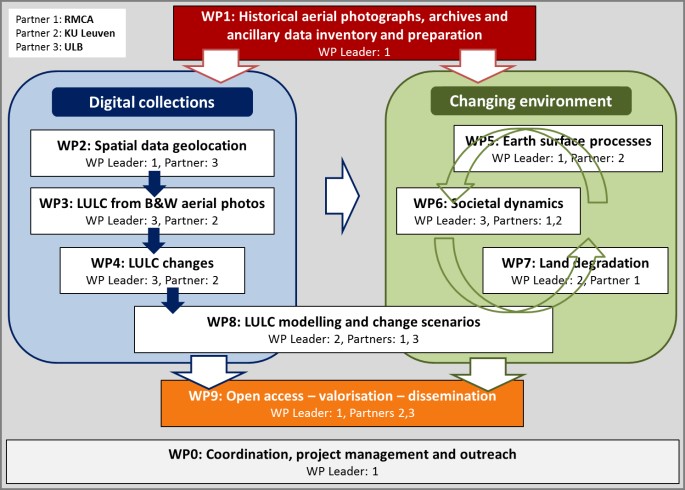
There are three transversal WPs: WP 1 provides the basic data that are the cornerstone of the project, WP 8 will integrate, through different modelling approaches, the outputs from the other WPs, and WP9 concerns the dissemination on the web of the georeferenced historical data and the produced maps in order to share data with the scientific community at large and also raise awareness of the importance of land use change to the general public, policymakers and land managers.
The other WPs are organized into two related groups, the first focusing on the production of a georeferenced digital collection directly from the historical data available at MRAC and the production of derived digital LULC products. The second group concerns the analysis of the changing environment. It involves several WPs that are strongly interconnected. The project goes across disciplines such as population science, geography, geomorphology, geomatics and remote sensing. WP 0 is transversal and deals with the management and valorization strategies.
CONSORTIUM
![]()


RESEARCH OUTPUTS
Data
- The panchromatic orthomosaic of the North Tanganyika-Kivu Rift Region is currently being extended and processed. We are planning to launch a web GIS where these data will become available (https://georiska.africamuseum.be/) towards the end of the PAStECA project end of 2022.
- Landslide susceptibility map: https://zenodo.org/record/5524161
- Shallow landslide inventory (7944 instances): https://zenodo.org/record/5027004
- 1958 forest data: https://zenodo.org/record/5027117
Scientific papers
- Maki Mateso, J.C., Bielders, C., Monsieurs, E., Depicker, A., Smets, B., Tambala, T., Bagalwa Mateso, L., Dewitte, O. (in preparation) Characteristics, distribution and susceptibility of natural and human-induced landslides in a tropical mountainous region: the Rift flank west of Lake Kivu (DR Congo).
- Kubwimana, D., Ait Brahim, L., Nkurunziza, P., Dille, A., Depicker, A., Nahimana, L., Abdelouafi, A., Dewitte, O. (2021) Characteristics and Distribution of Landslides in the Populated Hillslopes of Bujumbura, Burundi. Geosciences 11, 259. doi: https://doi.org/10.3390/geosciences11060259.
- Depicker, A., Jacobs, L., Mboga, N., Smets, B., Van Rompaey, A., Lennert, M., Wolff, E., Kervyn, F., Michellier, C., Dewitte, O., Govers, G. (2021). Historical dynamics of landslide risk from population and forest-cover changes in the Kivu Rift. Nature Sustainability. doi: https://doi.org/10.1038/s41893-021-00757-9.
- Mboga, N., Grippa, T., Georganos, S., Vanhuysse, S., Smets, B., Dewitte, O., Wolff, E., Lennert, M. (2021) Fully convolutional networks for land cover classification from historical panchromatic aerial photographs. ISPRS Journal of Photogrammetry and Remote Sensing 167, 385-395. doi: https://doi.org/10.1016/j.isprsjprs.2020.07.005.
- Depicker, A., Govers, G., Jacobs, L., Campforts, B., Uwihirwe, J., Dewitte, O. (2021). Interactions between deforestation, landscape rejuvenation, and shallow landslides in the North Tanganyika-Kivu Rift region, Africa. Earth Surface Dynamics 9, 445-462. doi: https://doi.org/10.5194/esurf-9-445-2021.
- Dewitte, O., Dille, A., Depicker, A., Kubwimana, D., Maki Mateso, J.-C., Mugaruka Bibyento, T., Uwihirwe, J., Monsieurs, E. (2021). Constraining landslide timing in a data-scarce context: from recent to very old processes in the tropical environment of the North Tanganyika-Kivu Rift region. Landslides 18, 161-177. doi: https://doi.org/10.1007/s10346-020-01452-0.
- Mboga, N., Grippa, T., Georganos, S., Vanhuysse, S., Smets, B., Dewitte, O., Wolff, E., Lennert, M. (2020). Fully convolutional networks for land cover classification from historical panchromatic aerial photographs. ISPRS Journal of Photogrammetry and Remote Sensing 167, 385-395. doi: https://doi.org/10.1016/j.isprsjprs.2020.07.005.
- Monsieurs, E., Dewitte, O., Depicker, A., Demoulin, A. (2019). Towards a transferable antecedent rainfall – susceptibility threshold approach for landsliding. Water 11, 2202. doi: https://doi.org/10.3390/w11112202.
- Depicker, A., Jacobs, L., Delvaux, D., Havenith, H.-B., Maki Mateso, J.-C., Govers, G., Dewitte, O. (2020). The added value of a regional landslide susceptibility assessment: the western branch of the East African Rift. Geomorphology 353, 106886. doi: https://doi.org/10.1016/j.geomorph.2019.106886.
- Mboga, N., Georganos, S., Grippa, T., Lennert, M., Vanhuysse, S., Wolff, E. Fully Convolutional Networks and Geographic Object-Based Image Analysis for the Classification of VHR Imagery. Remote Sens. 2019, 11, 597. doi: https://doi.org/10.3390/rs11050597.
- Dille, A., Kervyn, F., Bibentyo, T.M., Delvaux, D., Ganza, G.B., Mawe, G.I., Buzera, C.K., Nakito, E.S., Moeyersons, J., Monsieurs, E., Nzolang, C., Smets, B., Kervyn, M., Dewitte, O., 2019. Causes and triggers of deep-seated hillslope instability in the tropics–Insights from a 60-year record of Ikoma landslide (DR Congo). Geomorphology 345, 106835. doi: https://doi.org/10.1016/j.geomorph.2019.106835.
- Smets B., Michellier C., Syavulisembo A.M., Muganga G., d'Oreye N., Kervyn F. (2018) - Very high-resolution imaging of the city of Goma (North Kivu, D.R. Congo) using SfM-MVS photogrammetry. 2018 IEEE International Geoscience and Remote Sensing Symposium (IGARSS).
- Mboga, N., Georganos, S., Grippa, T., Lennert, M., Vanhuysse, S., Wolff, E. (2018) - Fully convolutional networks for the classification of aerial VHR imagery. GEOBIA 2018- Geobia in a Changing World, 2018, pp. 1–12.
For more information, please visit the PAStECA website.
Project description also available on the AfricaMuseum website.
![]()