Reading the Earth: GeoRiskA’s Research on Geohazards and Disaster Risks

On 22 April, we celebrate Earth Day. Since its first edition in 1970, Earth Day has become a key moment to reflect on our relationship with the planet, promote sustainability, and support initiatives that address environmental and climate change, biodiversity loss, pollution, and natural hazards.
At GeoRiskA, we are analysing the occurrence of geohazards—such as landslides, floods, gullies and volcanic activity—and studying their evolution. We are also investigating their impact on people and landscapes, with a focus on Africa and, more specifically, data-scarce regions of this continent. Our research combines remote sensing, historical archives, modelling, and field-based observations, including citizen science, to better understand how these hazards occur and evolve across space and time. On this Earth Day, we would like to highlight the importance of this work in changing environments, through key examples of our research topics and methods. Let’s dive into the world of GeoRiskA!
Compound hazard events
A compound hazard event happens when several natural hazards occur at the same time or in quick succession, often making the overall impact much worse. For example, during an intense rainstorm, landslides and flash floods can happen together in the same area. In these cases, landslides can feed the flash floods with large amount of debris scoured high in the slope, increasing the impacts on damaging roads, homes, and farmland all at once. These events are especially dangerous because they’re harder to predict and respond to than single hazards—and their combined effects can overwhelm communities and infrastructure. In addition, these hazards often strike within a short time and close space, leaving little time for warning or response.
In tropical Africa, the combination of intense rainfall, steep terrain, and growing populations living in vulnerable areas makes the region particularly susceptible to the compounding of multiple landslides (Fig. 1) or landslides and flash floods (Fig. 2). In many parts of tropical Africa, limited monitoring systems, scarce historical data and the year-round cloud coverage makes it especially hard to anticipate and manage these complex events. That’s why understanding compound hazards—and how they unfold across both space and time—is essential for protecting lives, livelihoods, and ecosystems in the region.
Figure 1 – Compounding landslide event that occurred in November 2020, near Katshungu, South Kivu, Democratic Republic of Congo. (Satellite images: © ESA Copernicus Sentinel-2 data; Source: A. Deijns – RMCA)
To better understand and mitigate these complex hazards, GeoRiskA leads the GEOTROP project (BELSPO BRAIN-be 2.0 programme). This initiative focuses on the western branch of the East African Rift, a tropical region especially susceptible and vulnerable to such compound events. GEOTROP aims to build a detailed regional inventory of landslides and flash floods, analyze how land use and climate influence their occurrence, and use that to project future risk hotspots. By combining satellite data, climate models, and citizen observations, the project seeks to improve early warning systems and support disaster risk reduction efforts in one of the world’s most hazard-prone yet under-monitored regions.
Figure 2 – Compound landslide and flash flood events that occurred west of Uvira, South Kivu, Democratic Republic of Congo. (Satellite images: © ESA Copernicus Sentinel-2 data; Source: A. Deijns – RMCA)
Time travelling through historical aerial photographs
The GeoRiskA team, together with the Collection Department of the AfricaMuseum, manages a collection of about 320,000 historical aerial photographs covering central Africa, and more specifically the Democratic Republic of Congo (DRC), Rwanda and Burundi. These aerial photos were acquired between the 1940s and 1980s, with most of the collection dating from the 1950s. These photos are generally copies of original collections available in the countries covered by the imagery. The photos are mostly in paper format, but some datasets are stored on glass plates (positives) or film media (negatives).
The GeoRiskA team is working on the digitizing and valorizing of this unique collection of historical aerial photos, as such imagery allows looking back in time and detecting environmental changes in the landscape, over a period that is much longer than what satellite-based analyses could offer.
Figure 3 – 1947-2017 urban expansion in the city centre of Goma, North Kivu, Democratic Republic of Congo. (source: B. Smets – RMCA/VUB)
One of GeoRiskA’s flagship contributions to understanding long-term landslide hazard trends is the work of Depicker et al. (2021), on the Kivu Rift Region. The GeoRiskA researchers, through the PASTeCA project (BELSPO BRAIN-be Programme), combined hundreds of scanned images from 1958 with satellite data to reconstruct nearly 60 years of forest-cover change and population expansion. This allowed them to track how deforestation and settlement on steep terrain have dramatically increased landslide risk over time—especially in eastern DRC, where risk levels are now twice as high as in neighboring countries. The study shows that historical archives, often underused in modern hazard science, can reveal how environmental degradation and human dynamics shape today’s disaster risks—and how they might evolve in the future.
Figure 4 – 1959-2020 forest cover and urban expansion in the Kivu (Democratic Republic of Congo and Rwanda). (source: A. Depicker – RMCA)
Another striking example of the power of historical aerial imagery comes from Bukavu, eastern DRC, where researchers, through the MODUS project (BELSPO STEREO-III Programme) analyzed over 70 years of hillslope transformation to understand the evolution of a massive, deep-seated landslide named ‘Funu’. By combining aerial photographs dating up to 1947 with modern satellite data, the study of Dille et al. (2022) revealed how unplanned urban growth progressively altered the hydrology of the slope—rerouting water through roads, pipes, and drainage systems. This human-induced reorganization led to a significant acceleration of the Funu landslide, particularly in the most urbanized sector. The work shows how seemingly gradual changes in land use can generate self-reinforcing feedback that amplify hazard risk over time. It highlights the importance of integrating long-term perspectives into urban planning and disaster mitigation strategies, especially in rapidly expanding tropical cities.
Figure 5 – The urban expansion of the Funu landslide, in Bukavu, South Kivu, Eastern Democratic Republic of Congo. (source: A. Dille – RMCA)
When AI can help us see geohazard distributions in space and time
One of the major challenges in studying geohazards is the scarcity of reliable and consistent data, especially in tropical regions like Central Africa. In this part of the world, limited access to ground-based monitoring networks, archival records, and detailed hazard inventories makes it difficult to assess the frequency, triggers, and impacts of events like landslides and floods. This lack of data hampers proper early warning systems, risk assessments, and informed planning, particularly in rapidly growing urban areas where vulnerability is increasing. Bridging these data gaps is essential to better understand how geohazards evolve in complex environments shaped by climate change, deforestation, and unplanned urbanization.
One approach that GeoRiskA started exploring is the use of Generative AI to analyse press articles to extract information about geohazards, in order to investigate the spatial and temporal distribution of these natural hazards. Through the GuiDANCE and GeoHaTACC projects, and a co-funding by the Vrije Universiteit Brussel, the GeoRiskA and VUB researchers are developing a semi-automated natural language processing (NLP) tool to address the under-reporting of geo-hydrological hazards (here, landslides, floods, and flash floods), at global scale (Fig. 6) and at the scale of tropical Africa. By leveraging fine-tuned large language models, this approach systematically extracts relevant information from online press articles. The process involves filtering content for relevance, extracting key details like location, timing, and impact, and organizing this information into a structured disaster database. This methodology aims to mitigate the systematic biases present in existing disaster datasets, which often overlook less-publicized events, thereby enhancing our understanding of hazard distribution in data-scarce regions.
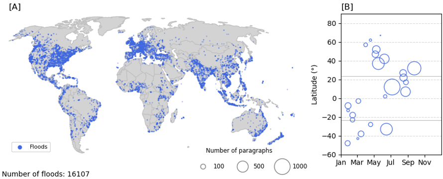
Figure 6 – 2020-2023 global flood events extracted from press articles using natural language processing (NLP) methods. Frame [A] shows the global distribution of these flood events on a map. Frame [B] shows their distribution in time and latitude. (source: B. Valkenborg – VUB/RMCA)
The expected future integration of this NLP-based approach with citizen science initiatives and remote sensing technologies offers a promising avenue for comprehensive hazard monitoring. Citizen science can provide localized, real-time observations, while remote sensing delivers broad spatial coverage and objective measurements. Combining these data sources can validate and enrich the information extracted through NLP, leading to more accurate and timely assessments of geo-hydrological hazards. This synergistic framework is particularly valuable in regions where traditional data collection is limited, enhancing disaster preparedness and resilience.
And much more...
The diversity of GeoRiskA's activities does not stop here. Citizen Observer Networks, training and capacity building activities, support to local studies are other examples of actions performed in collaboration with our African partners. We will be happy to share more in the future. In the meantime, if you have questions about our activities and research, do not hesitate to contact us!
Happy Earth Day!